Mouse Mat > Historic > Ancient civilizations > Roman Empire > Ancient Rome
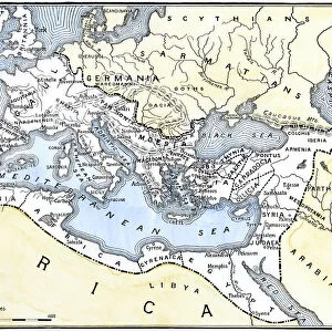
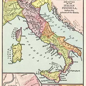
Mouse Mat : Map of Europe under the Roman Empire


![]()
Home Decor from North Wind
Map of Europe under the Roman Empire
Map of Europe in the time of the Roman Empire.
Printed color lithograph of a 19th-century illustration
North Wind Picture Archives brings history to life with stock images and hand-colored illustrations
Media ID 5877807
© North Wind Picture Archives
Ancient Ancient Civilization Ancient History Ancient Roman Ancient Rome Antiquity Britain British Isles Civilization Classical Classical Civilization England Europe European Gaul Italy Roman Roman Empire Rome Gallia Germania Iberia
Mouse Pad
Standard Size Mouse Pad 7.75" x 9..25". High density Neoprene w linen surface. Easy to clean, stain resistant finish. Rounded corners.
Archive quality photographic print in a durable wipe clean mouse mat with non slip backing. Works with all computer mice
Estimated Product Size is 23.7cm x 20.2cm (9.3" x 8")
These are individually made so all sizes are approximate
Artwork printed orientated as per the preview above, with landscape (horizontal) or portrait (vertical) orientation to match the source image.
FEATURES IN THESE COLLECTIONS
> Arts
> Artists
> R
> Roman Roman
> Europe
> Italy
> Lazio
> Rome
> Europe
> United Kingdom
> England
> Maps
> Historic
> Ancient civilizations
> Roman Empire
> Ancient Rome
> Historic
> Ancient civilizations
> Roman Empire
> Roman art
> Historic
> Ancient civilizations
> Roman Empire
> Historic
> Ancient civilizations
> Maps and Charts
> British Empire Maps
> Maps and Charts
> Early Maps
> North Wind Picture Archives
> Ancient history
> North Wind Picture Archives
> Maps
EDITORS COMMENTS
This vibrant and detailed print showcases a Map of Europe under the Roman Empire, providing a fascinating glimpse into the ancient world. The map, a printed color lithograph of a 19th-century illustration, captures the vast extent of the Roman Empire during its peak. Stretching from Britannia (modern-day Britain) in the west to Germania (Germany) in the north and Iberia (Spain) in the southwest, this map highlights Rome's dominance over much of Europe. It beautifully depicts major cities such as Rome itself, Gaul (France), and various regions that were once part of this mighty civilization. The artwork transports us back to classical times when ancient civilizations thrived across these lands. With intricate details and artistic flair, it offers an engaging visual representation of history for enthusiasts and scholars alike. As we explore this vintage masterpiece, we are reminded of how influential Rome was in shaping European culture, politics, and architecture. From its grand monuments to its advanced infrastructure systems like roads and aqueducts – all can be traced back to this remarkable era. Whether you are fascinated by ancient history or simply appreciate artistry depicting historic moments, this print is sure to spark your imagination as you delve into the rich tapestry that was Ancient Rome.
MADE IN THE USA
Safe Shipping with 30 Day Money Back Guarantee
FREE PERSONALISATION*
We are proud to offer a range of customisation features including Personalised Captions, Color Filters and Picture Zoom Tools
SECURE PAYMENTS
We happily accept a wide range of payment options so you can pay for the things you need in the way that is most convenient for you
* Options may vary by product and licensing agreement. Zoomed Pictures can be adjusted in the Cart.