Mouse Mat > Europe > United Kingdom > England > Derbyshire > Newton
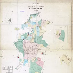
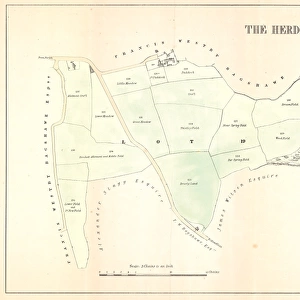
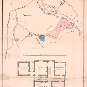
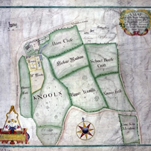
Mouse Mat : Norton, Derbyshire, surveyed by Joseph Dickinson, 1737


![]()
Home Decor from Sheffield City Archives
Norton, Derbyshire, surveyed by Joseph Dickinson, 1737
Full title: A map of all the lands belonging to Robert Newton esquire at Norton in the County of Derby, surveyed by Joseph Dickinson, 1737
Covers land between Norton Lane and School Lane (including Henley Avenue, Brocklehurst Avenue, The Meads, Cinderhill Lane, Cloonmore Drive, Cloonmoore Croft, Cypress Avenue, Norton Green Close).
Original at Sheffield Archives ref. arc00670
Sheffield City Archives and Local Studies Library has an unrivalled collection of images of Sheffield, England
Media ID 14045451
© Sheffield City Council
Anglican Avenue Churches Croft Green James Lane Maps Norton School Street Bowling Brocklehurst Cypress Greens Henley Meads Newton Schoolhouse
Mouse Pad
Standard Size Mouse Pad 7.75" x 9..25". High density Neoprene w linen surface. Easy to clean, stain resistant finish. Rounded corners.
Archive quality photographic print in a durable wipe clean mouse mat with non slip backing. Works with all computer mice
Estimated Product Size is 23.7cm x 20.2cm (9.3" x 8")
These are individually made so all sizes are approximate
Artwork printed orientated as per the preview above, with landscape (horizontal) orientation to match the source image.
FEATURES IN THESE COLLECTIONS
> Arts
> Artists
> R
> James Roberts
> Europe
> France
> Canton
> Landes
> Europe
> United Kingdom
> England
> Derbyshire
> Derby
> Europe
> United Kingdom
> England
> Derbyshire
> Newton
> Europe
> United Kingdom
> England
> Derbyshire
> Related Images
> Maps and Charts
> Related Images
> Sheffield City Archives
> Maps and Plans
> Maps of Derbyshire
EDITORS COMMENTS
This print takes us back to the year 1737, offering a glimpse into the historic town of Norton in Derbyshire. Surveyed by Joseph Dickinson, this meticulous map showcases all the lands owned by Robert Newton esquire at that time. The detailed depiction covers an extensive area between Norton Lane and School Lane, encompassing notable landmarks such as Henley Avenue, Brocklehurst Avenue, The Meads, Cinderhill Lane, Cloonmore Drive, Cloonmoore Croft, Cypress Avenue, and Norton Green Close. The image provides a fascinating insight into the layout and development of Norton during this period. It allows us to visualize how these streets were laid out and how they have evolved over time. Additionally, it highlights significant features like St. James Anglican Churches and the schoolhouse located within this vibrant community. Preserved at Sheffield Archives under reference arc00670, this original piece holds immense historical value for researchers and history enthusiasts alike. Its intricate details offer a unique opportunity to explore the past while appreciating the efforts of Joseph Dickinson in accurately surveying these lands
MADE IN THE USA
Safe Shipping with 30 Day Money Back Guarantee
FREE PERSONALISATION*
We are proud to offer a range of customisation features including Personalised Captions, Color Filters and Picture Zoom Tools
SECURE PAYMENTS
We happily accept a wide range of payment options so you can pay for the things you need in the way that is most convenient for you
* Options may vary by product and licensing agreement. Zoomed Pictures can be adjusted in the Cart.