
Maps Collection
Maps of Tonga Oceania are a great way to explore the islands of this Polynesian nation
Choose a picture from our Maps Collection for your Wall Art and Photo Gifts
10 items
All Professionally Made to Order for Quick Shipping
-
Maps Collection
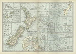
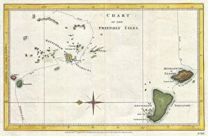
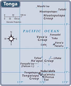
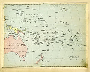
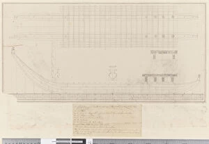
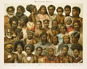
Maps of Tonga Oceania are a great way to explore the islands of this Polynesian nation. Located in the South Pacific Ocean, Tonga is made up of over 170 islands and islets, with a total land area of 747 square miles, and are help visitors to get an overview of the geography and topography of each island, as well as provide information on points of interest such as beaches, resorts, restaurants and other attractions. They also show roads and highways that connect the various islands together. In addition to physical maps showing terrain features such as rivers and mountains, there are also political maps which show boundaries between countries or provinces within Tonga. With so many different types available it's easy to find a map that suits your needs when planning a trip or exploring this beautiful part of Oceania.
+
Our beautiful pictures are available as Framed Prints, Photos, Wall Art and Photo Gifts
The Maps of Tonga Oceania collection from Media Storehouse is a stunning array of wall art and framed prints that showcase the beauty and diversity of this island nation. Our collection features a range of maps, including antique maps dating back to the 18th century, as well as more modern interpretations. Each map offers a unique perspective on Tonga's geography, history, and culture. The Maps of Tonga Oceania collection is perfect for anyone who loves travel or has an interest in cartography. These beautiful pieces are ideal for decorating homes or offices and make great gifts for friends and family members who appreciate fine art. Whether you're looking for a vintage map to add character to your living room or want to display a contemporary piece in your office, the Maps of Tonga Oceania collection has something for everyone. With its rich history and vibrant culture, Tonga is truly one-of-a-kind - just like these exquisite works of art.
+
What are Maps of Tonga Oceania art prints?
Maps of Tonga Oceania art prints are high-quality reproductions of maps depicting the islands and surrounding areas of Tonga, a Polynesian kingdom located in the South Pacific Ocean. These maps showcase the intricate details and features of this beautiful island nation, including its geography, topography, landmarks, and more. These art prints are perfect for anyone who loves history or geography or wants to add some unique decor to their home or office. They make great gifts for travelers or those with an interest in Oceania culture. Maps of Tonga Oceania art prints come in various sizes and styles to suit any taste or budget. We offer a wide selection of these stunning art prints that are printed on high-quality paper using state-of-the-art printing technology. Each print is carefully packaged to ensure it arrives at your doorstep in pristine condition. Whether you're looking for a vintage map or a modern interpretation, we have something for everyone.
+
What Maps of Tonga Oceania art prints can I buy from Media Storehouse?
We offer a wide range of Maps of Tonga Oceania art prints that are perfect for those who appreciate the beauty and culture of this island nation. These maps showcase the intricate details and unique features of Tonga, including its stunning coastline, lush forests, and vibrant coral reefs. Some popular options include vintage-style maps that capture the historical significance of Tonga's geography, as well as more modern designs that highlight its current landmarks and attractions. Many of these prints are available in a variety of sizes to suit any space or decor style. Whether you're looking to add some color to your home or office walls or simply want to celebrate your love for this beautiful country, we have plenty of Maps of Tonga Oceania art prints to choose from. With high-quality printing techniques and durable materials, these pieces are sure to become cherished additions to your collection.
+
How do I buy Maps of Tonga Oceania art prints?
To purchase Maps of Tonga Oceania art prints from Media Storehouse, you can browse our extensive collection of artwork online. Once you have found the print that you would like to purchase, simply add it to your cart and proceed to checkout. During the checkout process, you will be prompted to enter your shipping and payment information. We offer a variety of sizes for their art prints, so be sure to select the size that best fits your needs. We also offer a range of framing options if you prefer a ready-to-hang piece. If you have any questions or concerns about purchasing Maps of Tonga Oceania art prints from Media Storehouse, our customer service team is available to assist you via email or phone. With high-quality printing and fast shipping times, Media Storehouse makes it easy for customers around the world to enjoy beautiful artwork in their homes or offices.
+
How much do Maps of Tonga Oceania art prints cost?
As a provider of high-quality art prints, we offer a wide range of maps of Tonga Oceania at varying prices. The cost of these art prints depends on several factors such as the size, framing options, and materials used in printing. Generally, smaller sized maps are more affordable than larger ones due to the difference in production costs. Additionally, certain features like custom framing or mounting can also increase the price of an art print. However, you can rest assured that they are getting their money's worth with our commitment to providing only top-notch quality products. The cost of maps of Tonga Oceania art prints from Media Storehouse is reasonable and competitive within the market. You can browse through our extensive collection and find a piece that suits their budget without compromising on quality or aesthetics.
+
How will my Maps of Tonga Oceania art prints be delivered to me?
We take great care in ensuring that your Maps of Tonga Oceania art prints are delivered to you in the safest and most secure manner possible. We use high-quality packaging materials to protect your artwork during transit and ensure that it arrives at your doorstep undamaged. Your Maps of Tonga Oceania art prints will be shipped directly to you via our trusted delivery partners. Depending on your location, this may include local postal services or courier companies. You can track the progress of your order using a unique tracking number provided by us. We understand how important it is for you to receive your artwork promptly, which is why we strive to dispatch all orders as quickly as possible. Once dispatched, delivery times will vary depending on your location and chosen shipping method. Rest assured that when you order from Media Storehouse, we will do everything we can to ensure that your Maps of Tonga Oceania art prints arrive safely and securely at their destination.