Photo Mug > Asia > Sri Lanka > Maps
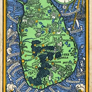
Photo Mug : Map of Southern India and Ceylon, after a work made circa 1720 by Dutch cartographer Adriaan Reland. Adams Bridge between the two nations is clearly marked


![]()
Home Decor from Design Pics
Map of Southern India and Ceylon, after a work made circa 1720 by Dutch cartographer Adriaan Reland. Adams Bridge between the two nations is clearly marked
Design Pics offers Distinctively Different Imagery representing over 1,500 contributors
Media ID 24903356
© Ken Welsh / Design Pics
18th Century Ceylon Chart Countries Geographical Geography Indian Ocean Islands Sri Lanka Tamil Nadu
Large Photo Mug (15 oz)
Add a touch of history to your morning routine with our Media Storehouse Photo Mug featuring a vintage map of Southern India and Ceylon. This beautiful design, inspired by a work created circa 1720 by Dutch cartographer Adriaan Reland, showcases intricate detail and accuracy, including the distinct marking of Adams Bridge connecting the two nations. Bring a piece of the past into your present and enjoy your favorite beverage while admiring this unique and captivating image. Perfect for history buffs, travel enthusiasts, or anyone who appreciates the beauty of old maps.
Elevate your coffee or tea experience with our premium white ceramic mug. Its wide, comfortable handle makes drinking easy, and you can rely on it to be both microwave and dishwasher safe. Sold in single units, preview may show both sides of the same mug so you can see how the picture wraps around.
Elevate your coffee or tea experience with our premium white ceramic mug. Its wide, comfortable handle makes drinking easy, and you can rely on it to be both microwave and dishwasher safe. Sold in single units, preview may show both sides of the same mug so you can see how the picture wraps around.
These are individually made so all sizes are approximate
FEATURES IN THESE COLLECTIONS
> Asia
> India
> Related Images
> Asia
> Sri Lanka
> Related Images
> Maps and Charts
> Early Maps
> Maps and Charts
> India
> Maps and Charts
> Related Images
EDITORS COMMENTS
This print showcases a historical map of Southern India and Ceylon, meticulously crafted by the renowned Dutch cartographer Adriaan Reland around 1720. The intricate details and exquisite artistry of this illustration make it an invaluable piece in understanding the geography and history of these nations. The highlight of this map is undoubtedly the Adams Bridge, prominently marked as a crucial link between these two countries. Also known as Rama Setu or Ramas Bridge, this natural formation connects Mannar Island in Sri Lanka to Tamil Nadu in Southern India, spanning across the mesmerizing Indian Ocean. Its presence on this map serves as a testament to its significance both geographically and culturally. As we delve into the past through this archival gem, we gain insights into how these regions were perceived during the 18th century. This old-world charm transports us back in time, allowing us to appreciate Welsh cartographer Adriaan Reland's dedication to capturing every minute detail with precision. Whether you are a history enthusiast or simply fascinated by maps and geography, this stunning print offers a glimpse into an era long gone. It serves as a reminder that our world has always been interconnected through land formations like Adams Bridge while showcasing the beauty and complexity of Southern India and Ceylon's landscapes.
MADE IN THE USA
Safe Shipping with 30 Day Money Back Guarantee
FREE PERSONALISATION*
We are proud to offer a range of customisation features including Personalised Captions, Color Filters and Picture Zoom Tools
SECURE PAYMENTS
We happily accept a wide range of payment options so you can pay for the things you need in the way that is most convenient for you
* Options may vary by product and licensing agreement. Zoomed Pictures can be adjusted in the Cart.