Photo Mug > Asia > India > Maps
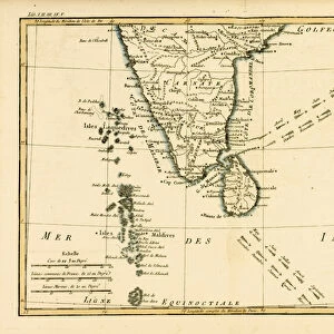
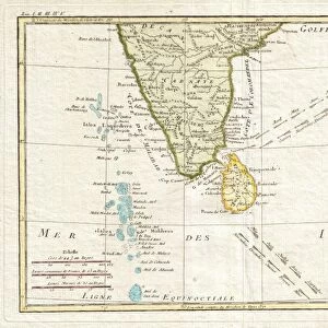
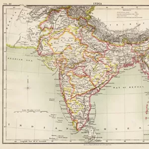
Photo Mug : Map Of Southern India, Circa. 1760. From "Atlas De Toutes Les Parties Connues Du Globe Terrestre "By Cartographer Rigobert Bonne. Published Geneva Circa. 1760


![]()
Home Decor from Design Pics
Map Of Southern India, Circa. 1760. From "Atlas De Toutes Les Parties Connues Du Globe Terrestre "By Cartographer Rigobert Bonne. Published Geneva Circa. 1760
Map Of Southern India, Circa.1760. From " Atlas De Toutes Les Parties Connues Du Globe Terrestre " By Cartographer Rigobert Bonne. Published Geneva Circa. 1760
Design Pics offers Distinctively Different Imagery representing over 1,500 contributors
Media ID 18186443
© Ken Welsh / Design Pics
Cartography Geography India Mapmaking Plate Southern
Large Photo Mug (15 oz)
Step back in time with our Media Storehouse Photo Mug featuring a captivating map of Southern India, taken from the 1760 publication of "Atlas De Toutes Les Parties Connues Du Globe Terrestre" by renowned cartographer Rigobert Bonne. This antique map, published in Geneva, showcases intricate details of the region during an era of exploration and discovery. Each mug in our Photo Mug collection holds your favorite beverage while allowing you to savor the history and beauty of this exquisite map design. Perfect for history buffs, travel enthusiasts, or anyone who appreciates the allure of the past, this mug makes a unique and thoughtful gift. Embrace the past, one sip at a time.
Elevate your coffee or tea experience with our premium white ceramic mug. Its wide, comfortable handle makes drinking easy, and you can rely on it to be both microwave and dishwasher safe. Sold in single units, preview may show both sides of the same mug so you can see how the picture wraps around.
Elevate your coffee or tea experience with our premium white ceramic mug. Its wide, comfortable handle makes drinking easy, and you can rely on it to be both microwave and dishwasher safe. Sold in single units, preview may show both sides of the same mug so you can see how the picture wraps around.
These are individually made so all sizes are approximate
FEATURES IN THESE COLLECTIONS
> Asia
> India
> Related Images
> Maps and Charts
> India
> Maps and Charts
> Related Images
EDITORS COMMENTS
This print showcases a beautifully detailed map of Southern India, circa 1760. Taken from the renowned "Atlas De Toutes Les Parties Connues Du Globe Terrestre" by cartographer Rigobert Bonne and published in Geneva around the same time, this piece is a true testament to the artistry and precision of historical mapmaking. The vibrant colors and intricate engravings bring this map to life, allowing us to explore the geography of Southern India as it was understood over two centuries ago. From its horizontal layout to its carefully crafted illustrations, every aspect of this print demonstrates the skill and dedication that went into creating such an invaluable resource. As we gaze upon this remarkable work, we are transported back in time, gaining insight into how our understanding of the world has evolved. It serves as a reminder of both our shared history and the importance of preserving these artifacts for future generations. Ken Welsh's expert reproduction captures every nuance and detail with utmost accuracy, ensuring that this piece remains accessible for all who appreciate its beauty. Whether you're an enthusiast of cartography or simply drawn to colorful illustrations, this print is sure to captivate your imagination and spark curiosity about Southern India's rich cultural heritage.
MADE IN THE USA
Safe Shipping with 30 Day Money Back Guarantee
FREE PERSONALISATION*
We are proud to offer a range of customisation features including Personalised Captions, Color Filters and Picture Zoom Tools
SECURE PAYMENTS
We happily accept a wide range of payment options so you can pay for the things you need in the way that is most convenient for you
* Options may vary by product and licensing agreement. Zoomed Pictures can be adjusted in the Cart.