Photo Mug > Africa > Morocco > Maps
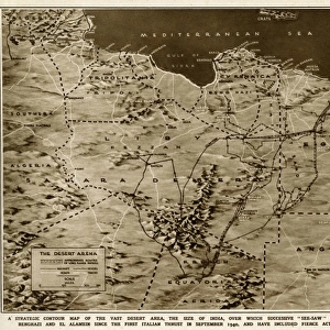
Photo Mug : The West Part Of Barbary Containing Fez Marocco Algier And Part Of Biledulgerid The Canary Islands Etc. Map From Circa 1720 By Hermann Moll


![]()
Home Decor from Design Pics
The West Part Of Barbary Containing Fez Marocco Algier And Part Of Biledulgerid The Canary Islands Etc. Map From Circa 1720 By Hermann Moll
Design Pics offers Distinctively Different Imagery representing over 1,500 contributors
Media ID 18188522
© Ken Welsh / Design Pics
18th Africa African Algeria Canary Islands Cartography Drawings Eighteenth Engravings Hermann Illustrations Moroccan Morocco North Prints Algerian Barbary Barbary Coast Marocco Moll
Large Photo Mug (15 oz)
Step back in time with our vintage-inspired Photo Mug from Media Storehouse. Featuring an intricately detailed map of The West Part of Barbary, including Fez, Marocco, Algier, and part of Biledulgerid, as well as the Canary Islands, this mug showcases an exquisite 1720 map by renowned cartographer Hermann Moll. Perfect for history buffs or anyone who appreciates the beauty of antique maps, this mug is not only a functional drinkware but also a stunning piece of art. Embrace the rich history of cartography with every sip.
Elevate your coffee or tea experience with our premium white ceramic mug. Its wide, comfortable handle makes drinking easy, and you can rely on it to be both microwave and dishwasher safe. Sold in single units, preview may show both sides of the same mug so you can see how the picture wraps around.
Elevate your coffee or tea experience with our premium white ceramic mug. Its wide, comfortable handle makes drinking easy, and you can rely on it to be both microwave and dishwasher safe. Sold in single units, preview may show both sides of the same mug so you can see how the picture wraps around.
These are individually made so all sizes are approximate
FEATURES IN THESE COLLECTIONS
> Africa
> Algeria
> Related Images
> Africa
> Morocco
> Related Images
> Maps and Charts
> Related Images
> Popular Themes
> North Island
EDITORS COMMENTS
This print takes us back to the 18th century, showcasing a detailed map of "The West Part Of Barbary". Created by renowned cartographer Hermann Moll around 1720, this illustration provides a fascinating glimpse into the African continent during that era. Stretching horizontally across the frame, the map highlights significant regions such as Fez, Marocco (Morocco), Algier (Algiers), and parts of Biledulgerid. The intricate engravings depict coastlines, rivers, mountains, and cities with remarkable precision. As we explore further south on this map, our eyes are drawn to the iconic Canary Islands off the western coast of Africa. Moll's expertise in cartography is evident in every stroke of his pen. His attention to detail transports us back in time and allows us to appreciate how maps were meticulously crafted centuries ago. This particular print captures not only geographical accuracy but also showcases artistic flair through its elegant illustrations. Ken Welsh has skillfully captured this historical masterpiece in stunning clarity for all to admire. Whether you're an avid collector or simply fascinated by history and exploration, this print is sure to be a conversation starter wherever it is displayed. So immerse yourself in the rich heritage of North Africa with "The West Part Of Barbary" - a true testament to Moll's genius and Welsh's talent for preserving history through art.
MADE IN THE USA
Safe Shipping with 30 Day Money Back Guarantee
FREE PERSONALISATION*
We are proud to offer a range of customisation features including Personalised Captions, Color Filters and Picture Zoom Tools
SECURE PAYMENTS
We happily accept a wide range of payment options so you can pay for the things you need in the way that is most convenient for you
* Options may vary by product and licensing agreement. Zoomed Pictures can be adjusted in the Cart.