Photo Mug > Arts > Landscape paintings > Waterfall and river artworks > River artworks
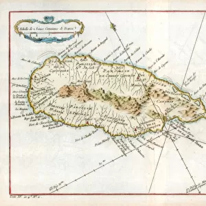
Photo Mug : Map of Peru, Guyana, Brazil and the Amazon regions (etching, 1730)
")
")
![]()
Home Decor from Fine Art Finder
Map of Peru, Guyana, Brazil and the Amazon regions (etching, 1730)
LRI4707065 Map of Peru, Guyana, Brazil and the Amazon regions (etching, 1730) by Delisle, Guillaume (1675-1726); Private Collection; (add.info.: Map of Peru, Guyana, Brazil and the Amazon regions - Strong water extracted from the " Atlas Nouveau containing all parts of the world" 1730 by Guillaume de L Isle (1675-1726)); Luisa Ricciarini; French, out of copyright
Media ID 23327034
© Luisa Ricciarini / Bridgeman Images
Atlas Book Brazil Bresilien Bresilienne Guyana Perou Peruvian Geographical Map
Large Photo Mug (15 oz)
Add a touch of history and culture to your daily routine with our Media Storehouse Photo Mugs. Featuring an exquisite etching of a map of Peru, Guyana, and the Amazon regions from 1730, this mug showcases the beauty and richness of South America. The intricate detail and vibrant colors of this map, created by Guillaume Delisle and beautifully captured by Luisa Ricciarini, will transport you to a time long past with every sip. A perfect gift for history enthusiasts, travelers, or anyone who appreciates the art of cartography, this mug is sure to become a cherished addition to your collection.
Elevate your coffee or tea experience with our premium white ceramic mug. Its wide, comfortable handle makes drinking easy, and you can rely on it to be both microwave and dishwasher safe. Sold in single units, preview may show both sides of the same mug so you can see how the picture wraps around.
Elevate your coffee or tea experience with our premium white ceramic mug. Its wide, comfortable handle makes drinking easy, and you can rely on it to be both microwave and dishwasher safe. Sold in single units, preview may show both sides of the same mug so you can see how the picture wraps around.
These are individually made so all sizes are approximate
FEATURES IN THESE COLLECTIONS
> Fine Art Finder
> Artists
> Frederick de Wit
> Fine Art Finder
> Artists
> Guillaume Delisle
> Animals
> Mammals
> Muridae
> Water Mouse
> Arts
> Art Movements
> Art Nouveau
> Arts
> Landscape paintings
> Waterfall and river artworks
> River artworks
> Maps and Charts
> Related Images
> Maps and Charts
> World
> South America
> Brazil
> Maps
> South America
> Brazil
> Related Images
EDITORS COMMENTS
This print showcases a remarkable etching from 1730, depicting the Map of Peru, Guyana, Brazil, and the Amazon regions. Created by the talented Guillaume de L'Isle (1675-1726), this map is an exquisite example of his cartographic expertise. The intricate details and precision in this engraving are truly awe-inspiring. The map itself is extracted from the "Atlas Nouveau containing all parts of the world" which was published in 1730. It offers a comprehensive view of South America's diverse landscapes and geographical features. From the mighty Amazon River to the sprawling forests of Brazil, every element has been meticulously depicted. As we delve into this historical artwork, we can appreciate its significance as a valuable resource for explorers and geographers during that time period. Its accuracy and attention to detail make it an invaluable tool for understanding these regions' topography. Luisa Ricciarini has expertly captured this piece through her lens, bringing out its rich colors and intricate lines. This photograph allows us to admire not only the artistry behind Delisle's work but also Ricciarini's talent in capturing its essence. With its timeless appeal and historical importance, this print serves as a testament to both artistic brilliance and scientific exploration—a true treasure for any lover of geography or history.
MADE IN THE USA
Safe Shipping with 30 Day Money Back Guarantee
FREE PERSONALISATION*
We are proud to offer a range of customisation features including Personalised Captions, Color Filters and Picture Zoom Tools
SECURE PAYMENTS
We happily accept a wide range of payment options so you can pay for the things you need in the way that is most convenient for you
* Options may vary by product and licensing agreement. Zoomed Pictures can be adjusted in the Cart.