Photo Mug > Africa > Ethiopia (Abyssinia) > Maps
Photo Mug : Map of Abyssinia (Ethiopia), 19th century (map)
, 19th century (map)")
, 19th century (map)")
![]()
Home Decor from Fine Art Finder
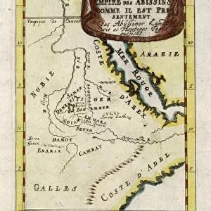
Map of Abyssinia (Ethiopia), 19th century (map)
6317642 Map of Abyssinia (Ethiopia), 19th century (map); (add.info.: Map of Abyssinia and the Adjacent Districts. From observations taken by British traveller and artist Henry Salt in 1809 and 1810. Drawn by J. Outhett and engraved by A. Macpherson. Published 1814. Used in Henry Salt's book A voyage to Abyssinia, and Travels into the Interior of that Country.); Photo © Ken Welsh. All rights reserved 2024
Media ID 38506190
© © Ken Welsh. All rights reserved 2024 / Bridgeman Images
Abyssinia Abyssinian Archival Archive Ethiopia Geographical Henry Salt Travels Trip Macpherson
Large Photo Mug (15 oz)
Sip your morning coffee in style with our Photo Mug featuring a stunning 19th-century map of Abyssinia (Ethiopia) by Ken Welsh. Perfect for history buffs and art lovers alike!
Elevate your coffee or tea experience with our premium white ceramic mug. Its wide, comfortable handle makes drinking easy, and you can rely on it to be both microwave and dishwasher safe. Sold in single units, preview may show both sides of the same mug so you can see how the picture wraps around.
Elevate your coffee or tea experience with our premium white ceramic mug. Its wide, comfortable handle makes drinking easy, and you can rely on it to be both microwave and dishwasher safe. Sold in single units, preview may show both sides of the same mug so you can see how the picture wraps around.
These are individually made so all sizes are approximate
FEATURES IN THESE COLLECTIONS
> Fine Art Finder
> Artists
> Richard Bridges Beechey
> Africa
> Ethiopia (Abyssinia)
> Maps
> Africa
> Ethiopia (Abyssinia)
> Related Images
> Africa
> Ethiopia
> Related Images
> Arts
> Artists
> Related Images
> Europe
> Germany
> Related Images
> Maps and Charts
> British Empire Maps
> Maps and Charts
> Early Maps
EDITORS COMMENTS
This stunning print captures a piece of history with the Map of Abyssinia (Ethiopia) from the 19th century. Created by British traveller and artist Henry Salt in 1809 and 1810, this map provides a detailed look at Abyssinia and its adjacent districts. Drawn by J. Outhett and engraved by A. Macpherson, this map was published in 1814 as part of Salt's book "A Voyage to Abyssinia, and Travels into the Interior of that Country."
The intricate details on this map showcase the geographical features of Abyssinia, offering a glimpse into the past and providing valuable insights into the region during that time period. From rivers to mountains, cities to villages, every aspect is meticulously depicted on this historical artifact.
As you gaze upon this image, you can't help but feel transported back in time to an era when exploration and discovery were at the forefront of human curiosity. The rich history contained within this map serves as a reminder of our collective past and highlights the importance of preserving such treasures for future generations to appreciate.
Whether you're a history buff, geography enthusiast, or simply someone who appreciates fine art, this Map of Abyssinia (Ethiopia) from the 19th century is sure to captivate your imagination and spark your sense of wonder about the world around us.
MADE IN THE USA
Safe Shipping with 30 Day Money Back Guarantee
FREE PERSONALISATION*
We are proud to offer a range of customisation features including Personalised Captions, Color Filters and Picture Zoom Tools
SECURE PAYMENTS
We happily accept a wide range of payment options so you can pay for the things you need in the way that is most convenient for you
* Options may vary by product and licensing agreement. Zoomed Pictures can be adjusted in the Cart.