Photo Mug > North America > Antigua and Barbuda > Maps
Photo Mug : Map of Antigua during the 18th Century


![]()
Home Decor from Fine Art Finder
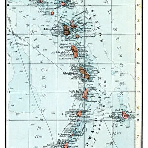
Map of Antigua during the 18th Century
3521866 Map of Antigua during the 18th Century; (add.info.: Map of Antigua during the 18th Century); Universal History Archive/UIG
Media ID 38416738
© Universal History Archive/UIG / Bridgeman Images
Large Photo Mug (15 oz)
Transport yourself back in time with our Photo Mug featuring a stunning map of Antigua during the 18th Century. Perfect for history buffs and art enthusiasts alike, this unique design is sure to make your morning coffee even more enjoyable.
Elevate your coffee or tea experience with our premium white ceramic mug. Its wide, comfortable handle makes drinking easy, and you can rely on it to be both microwave and dishwasher safe. Sold in single units, preview may show both sides of the same mug so you can see how the picture wraps around.
Elevate your coffee or tea experience with our premium white ceramic mug. Its wide, comfortable handle makes drinking easy, and you can rely on it to be both microwave and dishwasher safe. Sold in single units, preview may show both sides of the same mug so you can see how the picture wraps around.
These are individually made so all sizes are approximate
FEATURES IN THESE COLLECTIONS
> Fine Art Finder
> Costume & Fashion
> Maps and Charts
> Related Images
> North America
> Antigua and Barbuda
> Maps
EDITORS COMMENTS
This stunning print showcases a detailed map of Antigua during the 18th century, offering a fascinating glimpse into the island's history and geography. The intricate cartography and illustrated details bring to life the layout of this Caribbean gem, highlighting key landmarks and features that defined Antigua during this pivotal time period.
As we study this historical map, we are transported back in time to an era when exploration and colonization shaped the landscape of Antigua. The delicate lines and intricate illustrations on the map provide valuable insights into how the island was perceived and navigated by early explorers and settlers.
From its lush tropical forests to its pristine beaches, every corner of Antigua is meticulously depicted on this print. The attention to detail in capturing the essence of 18th-century Antigua is truly remarkable, allowing us to appreciate the rich history and cultural heritage of this enchanting island.
Whether you are a history buff, a cartography enthusiast, or simply someone who appreciates fine art, this print is sure to captivate your imagination and spark your curiosity about Antigua's past. It serves as a beautiful reminder of how maps can not only guide us geographically but also transport us through time to explore distant lands and cultures.
MADE IN THE USA
Safe Shipping with 30 Day Money Back Guarantee
FREE PERSONALISATION*
We are proud to offer a range of customisation features including Personalised Captions, Color Filters and Picture Zoom Tools
SECURE PAYMENTS
We happily accept a wide range of payment options so you can pay for the things you need in the way that is most convenient for you
* Options may vary by product and licensing agreement. Zoomed Pictures can be adjusted in the Cart.