Photo Mug > Maps and Charts > World
Photo Mug : Map of the world 1800


![]()
Home Decor from Fine Art Storehouse
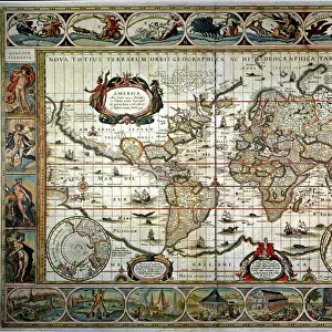
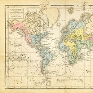
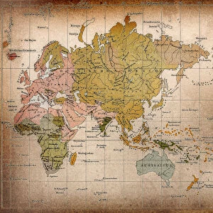
Map of the world 1800
Unleash your creativity and transform your space into a visual masterpiece!
THEPALMER
Media ID 15241435
© Roberto A Sanchez
Atlas Earth Map03 Oceania Paper Retro Revival World Map
Large Photo Mug (15 oz)
Introducing the Media Storehouse Photo Mug, featuring a captivating image of "Map of the World 1800" by THEPALMER from our Fine Art Storehouse collection. This unique mug brings history to life as you sip your favorite beverage, showcasing intricate details of the world as it was known over 200 years ago. Perfect for history enthusiasts, globetrotters, or anyone who appreciates the beauty of vintage maps, this mug is a must-have addition to your kitchen or office collection. Embrace the past and start your day with a journey around the world.
Elevate your coffee or tea experience with our premium white ceramic mug. Its wide, comfortable handle makes drinking easy, and you can rely on it to be both microwave and dishwasher safe. Sold in single units, preview may show both sides of the same mug so you can see how the picture wraps around.
Elevate your coffee or tea experience with our premium white ceramic mug. Its wide, comfortable handle makes drinking easy, and you can rely on it to be both microwave and dishwasher safe. Sold in single units, preview may show both sides of the same mug so you can see how the picture wraps around.
These are individually made so all sizes are approximate
FEATURES IN THESE COLLECTIONS
> Fine Art Storehouse
> The Magical World of Illustration
> Palmer Illustrated Collection
> Fine Art Storehouse
> Map
> Historical Maps
> Maps and Charts
> Related Images
> Maps and Charts
> World
EDITORS COMMENTS
In this print titled "Map of the World 1800" we are transported back in time to an era when cartography was a meticulous art form. The image showcases a beautifully preserved antique world map, exuding a sense of nostalgia and wonder. The attention to detail is striking as every contour and boundary is meticulously outlined on the aged paper. This retro revival piece takes us on a journey across continents, unveiling the physical geography that shaped our planet centuries ago. From the vast oceans to the sprawling landmasses, each element tells its own story. As we explore this vintage atlas, our eyes are drawn to Oceania, with its scattered islands dotting the Pacific Ocean like precious gems. The intricate depiction of Earth's seas invites us to imagine brave explorers sailing uncharted waters in search of new lands and adventures. "The Map of the World 1800" by THEPALMER captures not only historical accuracy but also evokes emotions associated with discovery and curiosity about our planet's past. It serves as a reminder that even in today's digital age, there is still something enchanting about holding an old-fashioned map in your hands. This stunning artwork from Fine Art Storehouse transports us back in time while reminding us of humanity's enduring fascination with maps and their ability to connect us all through space and time.
MADE IN THE USA
Safe Shipping with 30 Day Money Back Guarantee
FREE PERSONALISATION*
We are proud to offer a range of customisation features including Personalised Captions, Color Filters and Picture Zoom Tools
SECURE PAYMENTS
We happily accept a wide range of payment options so you can pay for the things you need in the way that is most convenient for you
* Options may vary by product and licensing agreement. Zoomed Pictures can be adjusted in the Cart.