Photo Mug > Africa > Related Images
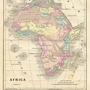
Photo Mug : Antique map of Africa


![]()
Home Decor from Fine Art Storehouse
Antique map of Africa
Illustration of a Antique map of Africa
Unleash your creativity and transform your space into a visual masterpiece!
Nastasic
Media ID 14719403
© This content is subject to copyright
Large Photo Mug (15 oz)
Add a touch of history and style to your daily routine with our Media Storehouse Antique Map of Africa Photo Mug. Featuring an exquisite antique map of Africa by Nastasic from our Fine Art Storehouse collection, this mug is not just a beverage holder, but a work of art. Each mug is printed with high-quality, vibrant colors that bring the intricate details of the map to life. Perfect for tea, coffee, or hot chocolate, this mug is a unique and thoughtful gift for history buffs, travel enthusiasts, or anyone who appreciates the beauty of fine art. Embrace the rich history of Africa with every sip.
Elevate your coffee or tea experience with our premium white ceramic mug. Its wide, comfortable handle makes drinking easy, and you can rely on it to be both microwave and dishwasher safe. Sold in single units, preview may show both sides of the same mug so you can see how the picture wraps around.
Elevate your coffee or tea experience with our premium white ceramic mug. Its wide, comfortable handle makes drinking easy, and you can rely on it to be both microwave and dishwasher safe. Sold in single units, preview may show both sides of the same mug so you can see how the picture wraps around.
These are individually made so all sizes are approximate
FEATURES IN THESE COLLECTIONS
> Fine Art Storehouse
> Map
> Historical Maps
> Africa
> Related Images
EDITORS COMMENTS
This print showcases an exquisite antique map of Africa, beautifully illustrated by the talented artist Nastasic. With its intricate details and vintage charm, this piece takes us on a journey back in time to explore the vast continent's rich history and diverse cultures. The map itself is a true work of art, meticulously crafted with precision and care. Every contour of the African landmass is delicately outlined, while rivers meander gracefully across its surface. The various countries are labeled in elegant calligraphy, offering glimpses into past colonial boundaries and ancient kingdoms that once thrived here. As we gaze upon this remarkable artwork, our imagination begins to wander through the untamed wilderness depicted on the map. We envision expeditions undertaken by explorers long ago who ventured into uncharted territories filled with exotic wildlife and hidden treasures waiting to be discovered. Beyond its historical significance, this antique map also serves as a reminder of Africa's enduring beauty and resilience. Its vibrant colors evoke images of sun-drenched savannas teeming with wildlife or lush rainforests brimming with life. Whether displayed in a study or living room, this stunning print will undoubtedly become a conversation starter for those who appreciate both artistry and geography. It invites us to embark on an imaginary voyage across Africa's breathtaking landscapes while honoring centuries-old cartographic traditions that have shaped our understanding of the world around us.
MADE IN THE USA
Safe Shipping with 30 Day Money Back Guarantee
FREE PERSONALISATION*
We are proud to offer a range of customisation features including Personalised Captions, Color Filters and Picture Zoom Tools
SECURE PAYMENTS
We happily accept a wide range of payment options so you can pay for the things you need in the way that is most convenient for you
* Options may vary by product and licensing agreement. Zoomed Pictures can be adjusted in the Cart.