Photo Mug > North America > United States of America > New York > New York > Maps
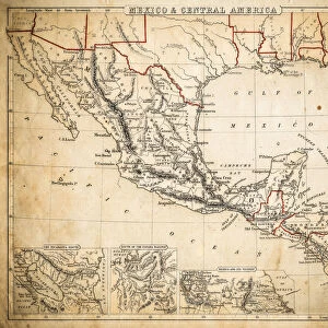
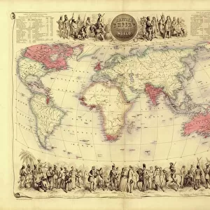
Photo Mug : Canada British America map of 1869


![]()
Home Decor from Fine Art Storehouse
Canada British America map of 1869
Cornells Grammar School Geography By S.S. Cornell - New York 1869
Unleash your creativity and transform your space into a visual masterpiece!
THEPALMER
Media ID 18106821
© 2014 Roberto Adrian Photography
Large Photo Mug (15 oz)
Add a touch of history to your morning routine with our Media Storehouse Photo Mugs, featuring the iconic Canada British America map of 1869 by THEPALMER from the Fine Art Storehouse. This vintage map, taken from Cornell's Grammar School Geography By S.S. Cornell - New York 1869, is sure to spark conversation and bring a sense of nostalgia to your day. Each mug is expertly printed with high-quality, fade-resistant technology to ensure your map design remains vibrant and clear, making it the perfect gift for history enthusiasts or anyone who appreciates the beauty of classic cartography.
Elevate your coffee or tea experience with our premium white ceramic mug. Its wide, comfortable handle makes drinking easy, and you can rely on it to be both microwave and dishwasher safe. Sold in single units, preview may show both sides of the same mug so you can see how the picture wraps around.
Elevate your coffee or tea experience with our premium white ceramic mug. Its wide, comfortable handle makes drinking easy, and you can rely on it to be both microwave and dishwasher safe. Sold in single units, preview may show both sides of the same mug so you can see how the picture wraps around.
These are individually made so all sizes are approximate
FEATURES IN THESE COLLECTIONS
> Fine Art Storehouse
> Map
> Historical Maps
> Maps and Charts
> Related Images
> North America
> Canada
> Maps
> North America
> Canada
> Related Images
> North America
> United States of America
> New York
> New York
> Maps
> North America
> United States of America
> New York
> Related Images
EDITORS COMMENTS
This print showcases a historical gem, the Canada British America map of 1869. A true testament to the rich tapestry of our past, this piece is taken from "Cornells Grammar School Geography" by S. S. Cornell - New York 1869. The intricate details and exquisite craftsmanship transport us back to an era when cartography was both an art form and a scientific endeavor. The map itself is a visual feast for the eyes, meticulously depicting the vast expanse of Canada's territories during that time. Every contour and boundary line tells a story of exploration, colonization, and cultural exchange. It serves as a window into an age where geographical knowledge was expanding rapidly. The choice to present this particular photograph in black and white adds depth and nostalgia to its overall aesthetic appeal. The monochromatic tones lend themselves perfectly to capturing the essence of history frozen in time. "ThePALMER" through their lens, has masterfully captured not only the physicality but also the spirit encapsulated within this vintage map print. This artwork invites us on a journey through time while simultaneously reminding us of how far we have come as nations united under one flag. Whether you are an avid historian or simply appreciate fine art with historical significance, this print promises to be an intriguing addition to any collection or space it graces – offering endless opportunities for reflection upon our shared heritage.
MADE IN THE USA
Safe Shipping with 30 Day Money Back Guarantee
FREE PERSONALISATION*
We are proud to offer a range of customisation features including Personalised Captions, Color Filters and Picture Zoom Tools
SECURE PAYMENTS
We happily accept a wide range of payment options so you can pay for the things you need in the way that is most convenient for you
* Options may vary by product and licensing agreement. Zoomed Pictures can be adjusted in the Cart.