Photo Mug > North America > Puerto Rico > Maps
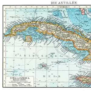
Photo Mug : Cuba and Puerto Rico map 1898


![]()
Home Decor from Fine Art Storehouse
Cuba and Puerto Rico map 1898
Unleash your creativity and transform your space into a visual masterpiece!
THEPALMER
Media ID 14757018
© This content is subject to copyright
Large Photo Mug (15 oz)
"Bring a piece of history to your morning routine with our Media Storehouse Photo Mug featuring the captivating "Cuba and Puerto Rico Map 1898" by THEPALMER from Fine Art Storehouse. This high-quality mug showcases intricate details of the map, making it a unique and thoughtful gift for history enthusiasts or avid travelers. Each mug is expertly printed using state-of-the-art technology to ensure vibrant colors and sharp details that will not fade or peel. Enjoy your favorite beverage while reliving the rich history of Cuba and Puerto Rico. Order yours today and add a touch of history to your daily life!"
Elevate your coffee or tea experience with our premium white ceramic mug. Its wide, comfortable handle makes drinking easy, and you can rely on it to be both microwave and dishwasher safe. Sold in single units, preview may show both sides of the same mug so you can see how the picture wraps around.
Elevate your coffee or tea experience with our premium white ceramic mug. Its wide, comfortable handle makes drinking easy, and you can rely on it to be both microwave and dishwasher safe. Sold in single units, preview may show both sides of the same mug so you can see how the picture wraps around.
These are individually made so all sizes are approximate
FEATURES IN THESE COLLECTIONS
> Fine Art Storehouse
> Map
> Historical Maps
> Maps and Charts
> Related Images
> North America
> Cuba
> Maps
> North America
> Cuba
> Related Images
> North America
> Puerto Rico
> Maps
> North America
> Puerto Rico
> Related Images
EDITORS COMMENTS
This print titled "Cuba and Puerto Rico map 1898" takes us back in time to a significant period in history. The image, captured by THEPALMER and available at Fine Art Storehouse, showcases an intricately detailed map from the year 1898. As we gaze upon this piece, we are transported to a time when Cuba and Puerto Rico were both under Spanish colonial rule. This particular era holds immense historical significance as it marks the end of the Spanish-American War and the beginning of a new chapter for these two Caribbean nations. The map itself is a testament to the artistry and precision of cartography during that era. Every contour, coastline, city, and river is meticulously depicted with remarkable attention to detail. It serves as a visual representation of how these islands were perceived over a century ago. Beyond its aesthetic appeal, this photograph also offers an opportunity for reflection on the complex histories shared between Cuba, Puerto Rico, Spain, and the United States during this transformative period. It invites us to explore questions about colonization, independence struggles, cultural identity shifts, and geopolitical changes that have shaped these countries' destinies. Whether you are an avid history enthusiast or simply appreciate fine art photography that tells compelling stories through visuals alone; this print is sure to captivate your imagination while serving as a timeless reminder of our interconnected pasts.
MADE IN THE USA
Safe Shipping with 30 Day Money Back Guarantee
FREE PERSONALISATION*
We are proud to offer a range of customisation features including Personalised Captions, Color Filters and Picture Zoom Tools
SECURE PAYMENTS
We happily accept a wide range of payment options so you can pay for the things you need in the way that is most convenient for you
* Options may vary by product and licensing agreement. Zoomed Pictures can be adjusted in the Cart.