Photo Mug > North America > United States of America > New York > New York > Maps
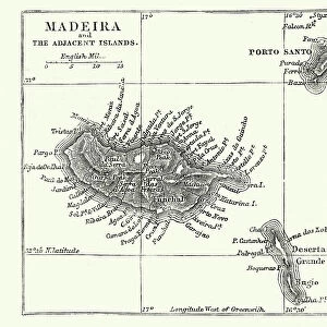
Photo Mug : Madeira island map 1883


![]()
Home Decor from Fine Art Storehouse
Madeira island map 1883
Encyclopedia Britannica 9th Edition New York Samuel L. Hall 1883 Vol XV
Unleash your creativity and transform your space into a visual masterpiece!
THEPALMER
Media ID 14756780
© This content is subject to copyright
Large Photo Mug (15 oz)
Introducing the Media Storehouse Photo Mug, featuring a stunning vintage map of Madeira Island from the Encyclopedia Britannica 9th Edition, published in New York in 1883. This exquisite design, "Madeira island map 1883" by THEPALER from the Fine Art Storehouse, showcases intricate details and historical charm, making it a perfect addition to your collection or a thoughtful gift for a history or travel enthusiast. Each mug is expertly crafted, ensuring a high-quality and durable product for daily use. Enjoy your favorite beverage while immersing yourself in the rich history of Madeira Island, as the vibrant and clear image transports you back in time.
Elevate your coffee or tea experience with our premium white ceramic mug. Its wide, comfortable handle makes drinking easy, and you can rely on it to be both microwave and dishwasher safe. Sold in single units, preview may show both sides of the same mug so you can see how the picture wraps around.
Elevate your coffee or tea experience with our premium white ceramic mug. Its wide, comfortable handle makes drinking easy, and you can rely on it to be both microwave and dishwasher safe. Sold in single units, preview may show both sides of the same mug so you can see how the picture wraps around.
These are individually made so all sizes are approximate
FEATURES IN THESE COLLECTIONS
> Fine Art Storehouse
> Map
> Historical Maps
> Maps and Charts
> Related Images
> North America
> United States of America
> New York
> New York
> Maps
> North America
> United States of America
> New York
> Related Images
EDITORS COMMENTS
In this photo print, titled "Madeira Island Map 1883" we are transported back in time to the late 19th century. The image showcases a meticulously detailed map of Madeira Island, taken from the Encyclopedia Britannica's 9th Edition published in New York by Samuel L. Hall in 1883. The map itself is a testament to the artistry and precision of cartography during that era. Every contour line, river, and coastal feature is intricately depicted with remarkable accuracy. It offers viewers a glimpse into the geographical layout of Madeira Island as it was known over a century ago. As we study this historical artifact, our imagination takes flight as we envision explorers and adventurers using similar maps to navigate their way through uncharted territories. We can almost feel their excitement and anticipation as they set sail towards new horizons. "ThePALMER" has expertly captured this piece of history through his lens, preserving its delicate details for generations to come. The composition is visually striking with its sepia tones evoking nostalgia while enhancing the vintage aesthetic. Whether you have an affinity for cartography or simply appreciate fine art photography, this print serves as both an educational tool and a beautiful decorative piece for any space. It invites us to reflect on how far we've come while honoring the rich heritage embedded within these antique maps.
MADE IN THE USA
Safe Shipping with 30 Day Money Back Guarantee
FREE PERSONALISATION*
We are proud to offer a range of customisation features including Personalised Captions, Color Filters and Picture Zoom Tools
SECURE PAYMENTS
We happily accept a wide range of payment options so you can pay for the things you need in the way that is most convenient for you
* Options may vary by product and licensing agreement. Zoomed Pictures can be adjusted in the Cart.