Photo Mug > Europe > France > Canton > Landes
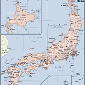
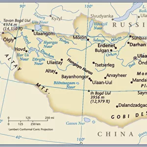
Photo Mug : Map of China and Japan, lithograph, published in 1875


![]()
Home Decor from Fine Art Storehouse
Map of China and Japan, lithograph, published in 1875
Map of China and Japan. Lithograph, published in 1875
Unleash your creativity and transform your space into a visual masterpiece!
Media ID 13666721
© ZU_09
Contour Drawing Country Geographic Area East Asian Culture Independent Mongolia Island Japan Japanese Culture Korea Land Pacific Ocean Sea Of Japan Or East Sea Taiwan Topographic Map Topography China East Asia Yellow Sea
Large Photo Mug (15 oz)
Step back in time with our exquisite Media Storehouse Photo Mug, featuring a captivating lithograph of a Map of China and Japan, published in 1875. This fine art mug showcases intricate details of the historic map, transporting you to a time of exploration and discovery. The high-quality print is vivid and clear, ensuring your favorite image is beautifully displayed every time you take a sip. A perfect blend of history and functionality, this unique mug makes for an exceptional gift or a delightful addition to your personal collection. Embrace the rich heritage of this stunning map and enjoy your favorite beverage in style.
Elevate your coffee or tea experience with our premium white ceramic mug. Its wide, comfortable handle makes drinking easy, and you can rely on it to be both microwave and dishwasher safe. Sold in single units, preview may show both sides of the same mug so you can see how the picture wraps around.
Elevate your coffee or tea experience with our premium white ceramic mug. Its wide, comfortable handle makes drinking easy, and you can rely on it to be both microwave and dishwasher safe. Sold in single units, preview may show both sides of the same mug so you can see how the picture wraps around.
These are individually made so all sizes are approximate
FEATURES IN THESE COLLECTIONS
> Fine Art Storehouse
> Map
> Historical Maps
> Arts
> Artists
> O
> Oceanic Oceanic
> Asia
> Japan
> Related Images
> Asia
> Mongolia
> Related Images
> Asia
> Taiwan
> Related Images
> Europe
> France
> Canton
> Landes
EDITORS COMMENTS
This lithograph, published in 1875, showcases a detailed Map of China and Japan. A true antique engraved image, it offers a glimpse into the rich history and ancient cultures of East Asia. The topography is meticulously depicted, highlighting key features such as the Yellow Sea and the Sea of Japan (also known as the East Sea). The map also includes Taiwan, an island that holds great significance in this region. As we explore this vertical composition, our eyes are drawn to Independent Mongolia nestled between Japan and China. This representation reminds us of the intricate geopolitical dynamics at play during that era. The horizontal expanse reveals vast stretches of land bordered by seas - a testament to the significant role played by these countries in shaping regional politics and trade routes. The Pacific Ocean majestically sprawls beyond their shores, symbolizing their connection to larger global networks. This contour drawing serves not only as a geographical reference but also as a visual time capsule capturing East Asian culture from over 140 years ago. It allows us to appreciate how these nations have evolved while still cherishing their deep-rooted traditions. Whether you are an enthusiast of history or simply captivated by beautiful cartographic artistry, this photograph transports you back to an era when maps were cherished artifacts representing knowledge and exploration.
MADE IN THE USA
Safe Shipping with 30 Day Money Back Guarantee
FREE PERSONALISATION*
We are proud to offer a range of customisation features including Personalised Captions, Color Filters and Picture Zoom Tools
SECURE PAYMENTS
We happily accept a wide range of payment options so you can pay for the things you need in the way that is most convenient for you
* Options may vary by product and licensing agreement. Zoomed Pictures can be adjusted in the Cart.