Photo Mug > Europe > France > Canton > Landes
Photo Mug : Map of the Scilly Isles


![]()
Home Decor from Fine Art Storehouse
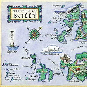
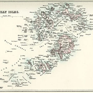
Map of the Scilly Isles
Vintage map from 1880 of the Scilly Isles an archipelago off the southwestern tip of the Cornish peninsula of Great Britain
Unleash your creativity and transform your space into a visual masterpiece!
duncan1890
Media ID 25128171
© Duncan Walker
Archipelago Image Created 1880 1889 Island Land Feature Navigational Equipment Past Styles Image Created 19th Century Isles Of Scilly Victorian Style
Large Photo Mug (15 oz)
Introducing the Media Storehouse Photo Mug featuring "Map of the Scilly Isles" by duncan1890 from our Fine Art Storehouse collection. This vintage map, dating back to 1880, showcases the captivating beauty of the Scilly Isles, an archipelago off the southwestern tip of Cornwall, Great Britain. Immerse yourself in history as you enjoy your favorite beverage from this high-quality mug. The vivid image is printed on both sides, ensuring the artwork is displayed in all its glory. Perfect for tea or coffee breaks, or as a thoughtful gift for a loved one, this unique mug is a must-have for anyone with a connection to the Scilly Isles or an appreciation for historical maps.
Elevate your coffee or tea experience with our premium white ceramic mug. Its wide, comfortable handle makes drinking easy, and you can rely on it to be both microwave and dishwasher safe. Sold in single units, preview may show both sides of the same mug so you can see how the picture wraps around.
Elevate your coffee or tea experience with our premium white ceramic mug. Its wide, comfortable handle makes drinking easy, and you can rely on it to be both microwave and dishwasher safe. Sold in single units, preview may show both sides of the same mug so you can see how the picture wraps around.
These are individually made so all sizes are approximate
FEATURES IN THESE COLLECTIONS
> Fine Art Storehouse
> Map
> Historical Maps
> Europe
> France
> Canton
> Landes
> Historic
> Historical fashion trends
> Victorian fashion trends
> Historic
> Victorian era fashion
> Maps and Charts
> Related Images
EDITORS COMMENTS
This vintage print takes us back to the 19th century, immersing us in the old-fashioned charm of a bygone era. The Map of the Scilly Isles, created in 1880, showcases the exquisite Victorian style that was prevalent during that time. As we gaze upon this antique piece, we are transported to an archipelago off the southwestern tip of Great Britain known as the Scilly Isles. The intricate details and craftsmanship of this map highlight its historical significance. It serves as a testament to navigational equipment used during that period and offers a glimpse into how these islands were perceived over a century ago. Each island is meticulously depicted, capturing their unique land features and captivating beauty. As we explore this image further, it becomes evident that it holds more than just geographical information; it encapsulates a rich history waiting to be discovered. This print invites us to delve into tales from the past - stories of sailors navigating treacherous waters or locals going about their daily lives on these idyllic isles. Duncan1890's creation allows us to appreciate not only his artistic talent but also provides an opportunity for reflection on our connection with history. This photograph transports us back in time while reminding us of how far we have come since then. It serves as a reminder that even amidst modernity, there will always be value in preserving and cherishing our heritage.
MADE IN THE USA
Safe Shipping with 30 Day Money Back Guarantee
FREE PERSONALISATION*
We are proud to offer a range of customisation features including Personalised Captions, Color Filters and Picture Zoom Tools
SECURE PAYMENTS
We happily accept a wide range of payment options so you can pay for the things you need in the way that is most convenient for you
* Options may vary by product and licensing agreement. Zoomed Pictures can be adjusted in the Cart.