Photo Mug > Arts > Street art graffiti > Digital art > Vector illustrations
Photo Mug : Brookings South Dakota US City Street Map


![]()
Home Decor from Fine Art Storehouse
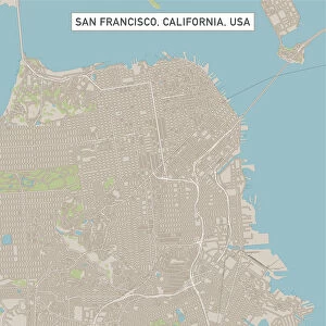
Brookings South Dakota US City Street Map
Vector Illustration of a City Street Map of Brookings, South Dakota, USA. Scale 1:60, 000.
All source data is in the public domain.
U.S. Geological Survey, US Topo
Used Layers:
USGS The National Map: National Hydrography Dataset (NHD)
USGS The National Map: National Transportation Dataset (NTD)
Unleash your creativity and transform your space into a visual masterpiece!
Frank Ramspott
Media ID 15215806
© Frank Ramspott, all rights reserved
Aerial View City Map Computer Graphic Directly Above Downtown District Gray Road Map South Dakota Text Brookings Digitally Generated Image Green Color White Color
Large Photo Mug (15 oz)
"Add a personal touch to your morning routine with our Media Storehouse Photo Mugs. Featuring the stunning "Brookings South Dakota US City Street Map" by Frank Ramspott from Fine Art Storehouse, these mugs are not just functional but also a work of art. Each mug showcases a detailed vector illustration of the city map of Brookings, South Dakota, USA, at a scale of 1:60,000. With all source data in the public domain, you can enjoy your favorite beverage while reminiscing about your travels or dreaming of new adventures in this charming city. Order yours today and make every sip an opportunity to relive the memories or plan your next adventure in Brookings, South Dakota."
Elevate your coffee or tea experience with our premium white ceramic mug. Its wide, comfortable handle makes drinking easy, and you can rely on it to be both microwave and dishwasher safe. Sold in single units, preview may show both sides of the same mug so you can see how the picture wraps around.
Elevate your coffee or tea experience with our premium white ceramic mug. Its wide, comfortable handle makes drinking easy, and you can rely on it to be both microwave and dishwasher safe. Sold in single units, preview may show both sides of the same mug so you can see how the picture wraps around.
These are individually made so all sizes are approximate
FEATURES IN THESE COLLECTIONS
> Fine Art Storehouse
> Map
> Street Maps
> Fine Art Storehouse
> Map
> USA Maps
> Aerial Photography
> Related Images
> Animals
> Insects
> Hemiptera
> Green Scale
> Arts
> Contemporary art
> Digital artwork
> Street art
> Arts
> Street art graffiti
> Digital art
> Digital paintings
> Arts
> Street art graffiti
> Digital art
> Vector illustrations
> Maps and Charts
> Geological Map
> Maps and Charts
> Related Images
> North America
> United States of America
> Lakes
> Related Images
> North America
> United States of America
> Maps
> North America
> United States of America
> South Dakota
> Related Images
EDITORS COMMENTS
This print showcases a meticulously detailed vector illustration of the charming city street map of Brookings, South Dakota, USA. With a scale of 1:60,000, every intricate element is brought to life in this visually stunning artwork. The source data used for this masterpiece is all in the public domain and comes from reputable sources such as the U. S. Geological Survey and US Topo. The various layers utilized include the USGS National Hydrography Dataset (NHD) and National Transportation Dataset (NTD), ensuring accuracy and precision in depicting water bodies, roads, streets, and transportation networks within Brookings. The image encompasses not only the downtown district but also highlights other prominent features like lakes and rivers that add to the natural beauty of this vibrant city. The digitally generated design presents an aerial view directly above Brookings with text labels elegantly incorporated into shades of gray, blue, white, and green colors. With no people present in this composition, it allows viewers to focus solely on appreciating the artistry behind this cartographic marvel. This print by Frank Ramspott captures both physical geography and computer graphics seamlessly merged together. Perfect for enthusiasts of maps or those with a connection to Brookings or South Dakota's rich history - this fine art piece will surely make a striking addition to any space it graces.
MADE IN THE USA
Safe Shipping with 30 Day Money Back Guarantee
FREE PERSONALISATION*
We are proud to offer a range of customisation features including Personalised Captions, Color Filters and Picture Zoom Tools
SECURE PAYMENTS
We happily accept a wide range of payment options so you can pay for the things you need in the way that is most convenient for you
* Options may vary by product and licensing agreement. Zoomed Pictures can be adjusted in the Cart.