Photo Mug > Europe > United Kingdom > England > London > River Thames
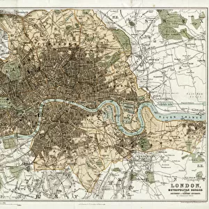
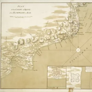
Photo Mug : London and Environs Historical Map, Engraving, 1892


![]()
Home Decor from Fine Art Storehouse
London and Environs Historical Map, Engraving, 1892
Very rare, beautifully detailed engraving of London and Environs Historical Map, Engraving, Published in 1892. Original edition from my own archives. Copyright has expired on this artwork. Digitally restored
Unleash your creativity and transform your space into a visual masterpiece!
bauhaus1000
Media ID 13609141
© This content is subject to copyright
18th Century Art Product Chart Colors Geographical Border Graph Land London England Public Park Residential District Thames River Topography View Into Land Multi Colored
Large Photo Mug (15 oz)
Step back in time with our Media Storehouse Photo Mug featuring a stunning, vintage engraving of London and Environs Historical Map from 1892. This rare and intricately detailed map, created by bauhaus1000 from the Fine Art Storehouse, showcases the historical charm of London over a century ago. With copyright expired, you can now enjoy this beautiful piece of history every day from the comfort of your mug. Perfect for tea or coffee, this mug is not only a functional addition to your kitchen but also a unique conversation starter. Bring history to life with our Photo Mug.
Elevate your coffee or tea experience with our premium white ceramic mug. Its wide, comfortable handle makes drinking easy, and you can rely on it to be both microwave and dishwasher safe. Sold in single units, preview may show both sides of the same mug so you can see how the picture wraps around.
Elevate your coffee or tea experience with our premium white ceramic mug. Its wide, comfortable handle makes drinking easy, and you can rely on it to be both microwave and dishwasher safe. Sold in single units, preview may show both sides of the same mug so you can see how the picture wraps around.
These are individually made so all sizes are approximate
FEATURES IN THESE COLLECTIONS
> Fine Art Storehouse
> Map
> Historical Maps
> Fine Art Storehouse
> Map
> USA Maps
> Animals
> Mammals
> Muridae
> Water Mouse
> Arts
> Contemporary art
> Digital artwork
> Street art
> Arts
> Landscape paintings
> Waterfall and river artworks
> River artworks
> Arts
> Photorealistic artworks
> Detailed art pieces
> Masterful detailing in art
> Arts
> Portraits
> Pop art gallery
> Street art portraits
> Arts
> Street art graffiti
> Digital art
> Digital paintings
> Europe
> France
> Canton
> Landes
> Europe
> United Kingdom
> England
> London
> River Thames
> Europe
> United Kingdom
> England
> Maps
> Europe
> United Kingdom
> England
> Rivers
EDITORS COMMENTS
This incredibly rare and exquisitely detailed engraving of the "London and Environs Historical Map" takes us back to the enchanting streets of 19th-century London. Published in 1892, this original edition from my personal archives showcases a piece of history that has captivated art enthusiasts for generations. The copyright on this artwork has expired, allowing us to digitally restore it to its former glory. Every intricate line and delicate etching has been carefully preserved, bringing to life the bustling residential districts, charming public parks, and meandering Thames River that defined London during this era. As you explore this print, you'll be transported through time as you trace the geographical borders and navigate the winding streets that once thrived with horse-drawn carriages and Victorian elegance. The vibrant colors used in this multi-colored masterpiece add depth and vibrancy to every corner of the map. Immerse yourself in the rich history captured within these pages - from landmarks that have stood for centuries to neighborhoods transformed by progress. This antique work of art is not just a map but a window into an era long gone yet forever cherished. Whether you are an avid collector or simply appreciate fine craftsmanship, this historical engraving is sure to become a treasured addition to your collection. Let it transport you back in time as you marvel at London's past beauty through the eyes of bauhaus1000.
MADE IN THE USA
Safe Shipping with 30 Day Money Back Guarantee
FREE PERSONALISATION*
We are proud to offer a range of customisation features including Personalised Captions, Color Filters and Picture Zoom Tools
SECURE PAYMENTS
We happily accept a wide range of payment options so you can pay for the things you need in the way that is most convenient for you
* Options may vary by product and licensing agreement. Zoomed Pictures can be adjusted in the Cart.