Photo Mug > Arts > Artists > C > Juan de la Cosa
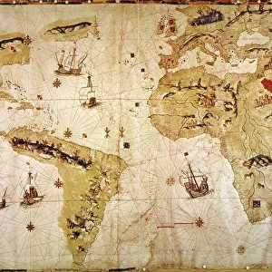
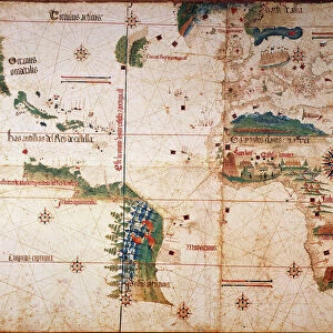
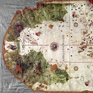
Photo Mug : NINA: WORLD MAP, 1500. World map, 1500, of Juan de la Cosa, navigator on the Nina on Christopher Columbus second voyage


![]()
Home Decor from Granger
NINA: WORLD MAP, 1500. World map, 1500, of Juan de la Cosa, navigator on the Nina on Christopher Columbus second voyage
NINA: WORLD MAP, 1500. World map, 1500, of Juan de la Cosa, navigator on the Nina on Christopher Columbus second voyage of 1493-94
Granger holds millions of images spanning more than 25,000 years of world history, from before the Stone Age to the dawn of the Space Age
Media ID 6622077
1500 Africa Age Of Discovery Asia Bradley Smith Caribbean Cartography Christopher Columbus Expedition Exploration Explorer Juan New World Nina Portolan Chart Spain Spanish World Cosa
Large Photo Mug (15 oz)
"Add a touch of history to your daily routine with our Media Storehouse Photo Mugs. Featuring the captivating "Nina: World Map, 1500" by Juan de la Cosa, this mug showcases an intricately detailed world map from the era of Christopher Columbus' second voyage. The Granger Collection's artwork beautifully adorns the mug, bringing a piece of history right to your hands. Sip your favorite beverage while exploring the wonders of the old world, one sip at a time. A perfect gift for history enthusiasts and collectors alike. "
Elevate your coffee or tea experience with our premium white ceramic mug. Its wide, comfortable handle makes drinking easy, and you can rely on it to be both microwave and dishwasher safe. Sold in single units, preview may show both sides of the same mug so you can see how the picture wraps around.
Elevate your coffee or tea experience with our premium white ceramic mug. Its wide, comfortable handle makes drinking easy, and you can rely on it to be both microwave and dishwasher safe. Sold in single units, preview may show both sides of the same mug so you can see how the picture wraps around.
These are individually made so all sizes are approximate
FEATURES IN THESE COLLECTIONS
> Granger Art on Demand
> Maps
> Animals
> Mammals
> Soricidae
> Navigator
> Arts
> Art Movements
> Renaissance Art
> Arts
> Artists
> C
> Juan de la Cosa
> Europe
> Spain
> Related Images
> Maps and Charts
> Early Maps
> Maps and Charts
> Related Images
EDITORS COMMENTS
This print titled "NINA: WORLD MAP, 1500" takes us back to the early years of exploration and discovery. Created by Juan de la Cosa, a skilled navigator on Christopher Columbus' second voyage in 1493-94, this world map offers a glimpse into the Renaissance era of cartography. The intricate details showcased in this print highlight the ambition and curiosity that fueled expeditions during the Age of Discovery. As we study the map, we can trace Columbus' journey across the vast Atlantic Ocean towards uncharted territories. The Caribbean islands emerge as key landmarks, representing new lands encountered by European explorers. The artist's skillful rendering transports us to an era when maps were not only tools for navigation but also works of art. With delicate brushstrokes and precise attention to detail, Juan de la Cosa captures Africa's coastline extending eastward towards Asia while Spain proudly stands at its center. This remarkable piece from Bradley Smith's Carousel Collection invites us to reflect on humanity's insatiable thirst for knowledge and adventure. It serves as a reminder that it was through courageous individuals like Columbus and his crew aboard the Nina that our understanding of the world expanded exponentially. As we admire this historical artifact turned artwork, let us appreciate both its aesthetic beauty and its significance in shaping our collective history.
MADE IN THE USA
Safe Shipping with 30 Day Money Back Guarantee
FREE PERSONALISATION*
We are proud to offer a range of customisation features including Personalised Captions, Color Filters and Picture Zoom Tools
SECURE PAYMENTS
We happily accept a wide range of payment options so you can pay for the things you need in the way that is most convenient for you
* Options may vary by product and licensing agreement. Zoomed Pictures can be adjusted in the Cart.