Photo Mug > Animals > Mammals > Cats (Domestic) > Russian Blue
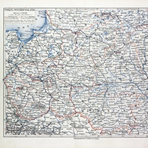
Photo Mug : Map illustrating the Brest-Litovsk Treaties, First World War, c1918, (c1920). Creator: Unknown
. Creator: Unknown")
. Creator: Unknown")
![]()
Home Decor from Heritage Images
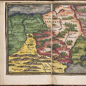
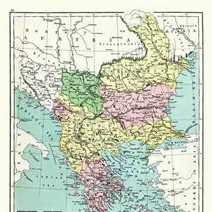
Map illustrating the Brest-Litovsk Treaties, First World War, c1918, (c1920). Creator: Unknown
Map illustrating the Brest-Litovsk Treaties, First World War, c1918, (c1920). Pink: Areas taken by Germany ; dark blue: Nationalities of self-determination ; light blue: Area to be evacuated by Germany. The Treaty of Brest-Litovsk, also known as the Brest Peace in Russia, was a peace treaty signed on 3 March 1918 between the new Bolshevik government of Russia and the Central Powers (German Empire, Austria-Hungary, Bulgaria, and the Ottoman Empire), that ended Russias participation in World War I. From " The Great World War: A History", Volume VII, edited by Frank A Mumby. [The Gresham Publishing Company Ltd, London, c1920]
Heritage Images features heritage image collections
Media ID 19666009
© The Print Collector/Heritage Images
Belarus Black Sea Eastern Europe Finland Frank A Frank A Mumby Frank Arthur Frank Arthur Mumby Front Line Frontline Gresham Publishing Co Ltd Gresham Publishing Company Keystone Archives Lines Mumby Mumby Frank A Mumby Frank Arthur Peace Treaty Poland Position Positions The Great World War A History Theatre Of War Treaty Treaty Of Brest Litovsk Ukraine Battlefield
Large Photo Mug (15 oz)
Step back in time with our Media Storehouse Photo Mug, featuring an intriguing historical map from the First World War era. This captivating illustration depicts the Brest-Litovsk Treaties of 1918, showcasing the territorial changes and self-determination areas in shades of pink, blue, and light blue. Bring a piece of history to your daily routine, as you savor your favorite beverage from this unique and informative mug. Perfect for history enthusiasts, collectors, or anyone who appreciates the richness of the past. Note: Creator and year of the original map are unknown.
Elevate your coffee or tea experience with our premium white ceramic mug. Its wide, comfortable handle makes drinking easy, and you can rely on it to be both microwave and dishwasher safe. Sold in single units, preview may show both sides of the same mug so you can see how the picture wraps around.
Elevate your coffee or tea experience with our premium white ceramic mug. Its wide, comfortable handle makes drinking easy, and you can rely on it to be both microwave and dishwasher safe. Sold in single units, preview may show both sides of the same mug so you can see how the picture wraps around.
These are individually made so all sizes are approximate
FEATURES IN THESE COLLECTIONS
> Animals
> Mammals
> Cats (Domestic)
> Russian Blue
> Europe
> Austria
> Related Images
> Europe
> Belarus
> Related Images
> Europe
> Bulgaria
> Related Images
EDITORS COMMENTS
This print showcases a map illustrating the Brest-Litovsk Treaties during the First World War, dating back to around 1918. The creator of this remarkable piece remains unknown, adding an air of mystery and intrigue to its historical significance. The colors used in the map provide crucial information about the territorial changes resulting from this treaty. The pink areas represent territories taken by Germany, highlighting their gains during this tumultuous period. Meanwhile, dark blue regions indicate nationalities seeking self-determination, emphasizing the diverse ethnic groups involved in these negotiations. Additionally, light blue sections depict areas that were to be evacuated by Germany as part of the agreement. Known as both the Brest-Litovsk Treaty and Brest Peace within Russia, it was signed on March 3rd, 1918 between Russia's new Bolshevik government and the Central Powers (German Empire, Austria-Hungary, Bulgaria, and Ottoman Empire). This significant treaty effectively marked Russia's exit from World War I. Taken from "The Great World War: A History" edited by Frank A Mumby and published by The Gresham Publishing Company Ltd in London around 1920s; this print is a valuable historical artifact offering insights into one of history's most transformative conflicts. Its presence serves as a reminder of how political agreements can reshape entire nations' destinies amidst times of turmoil and upheaval.
MADE IN THE USA
Safe Shipping with 30 Day Money Back Guarantee
FREE PERSONALISATION*
We are proud to offer a range of customisation features including Personalised Captions, Color Filters and Picture Zoom Tools
SECURE PAYMENTS
We happily accept a wide range of payment options so you can pay for the things you need in the way that is most convenient for you
* Options may vary by product and licensing agreement. Zoomed Pictures can be adjusted in the Cart.