Photo Mug > Animals > Mammals > Muridae > Desert Mouse
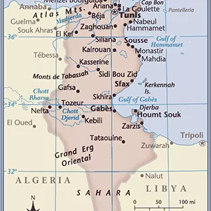
Photo Mug : Relief Map of Berberie, 1914. Creator: Unknown


![]()
Home Decor from Heritage Images
Relief Map of Berberie, 1914. Creator: Unknown
Relief Map of Berberie, 1914. From "Grande Geographie Bong Illustree", 1914
Heritage Images features heritage image collections
Media ID 36294497
© The Print Collector/Heritage Images
Algeria Africa Atlantic Ocean Atlas Mountains Berber Cartography Colonies Colony Desert Map Making Mapmaking Mediterranean Sea Morocco North Africa Mountain Range North Africa North African Ocean Sahara Sahara Desert Africa Barbary Coast Berbers Relief Map
Large Photo Mug (15 oz)
Add a touch of history to your morning routine with our Media Storehouse Photo Mug featuring a captivating Relief Map of Berberie from 1914. This vintage map, sourced from Heritage Images, showcases intricate details and is a fascinating glimpse into the past. Each mug is expertly printed with high-quality images, ensuring your favorite historical maps remain vibrant and clear even after multiple uses. Perfect for history enthusiasts, cartography lovers, or anyone who appreciates the beauty of old maps, our Photo Mugs make for unique and thoughtful gifts. Embrace the richness of the past with every sip.
Elevate your coffee or tea experience with our premium white ceramic mug. Its wide, comfortable handle makes drinking easy, and you can rely on it to be both microwave and dishwasher safe. Sold in single units, preview may show both sides of the same mug so you can see how the picture wraps around.
Elevate your coffee or tea experience with our premium white ceramic mug. Its wide, comfortable handle makes drinking easy, and you can rely on it to be both microwave and dishwasher safe. Sold in single units, preview may show both sides of the same mug so you can see how the picture wraps around.
These are individually made so all sizes are approximate
FEATURES IN THESE COLLECTIONS
> Africa
> Algeria
> Related Images
> Africa
> Morocco
> Related Images
> Africa
> Tunisia
> Related Images
> Animals
> Mammals
> Muridae
> Desert Mouse
EDITORS COMMENTS
This Relief Map of Berberie, created in 1914, showcases the intricate geographical features of the North African region, specifically focusing on Algeria, Morocco, and Tunisia. The map is an exquisite example of cartography from the early 20th century, produced during the height of European colonialism. The map reveals the intricate details of the North African coastline, with the Atlantic Ocean to the west and the Mediterranean Sea to the north. The Atlas Mountains, a significant mountain range stretching across Morocco and Algeria, are prominently depicted, their peaks rising majestically against the backdrop of the Sahara Desert. The Berber people, the indigenous inhabitants of the region, are represented by the name "Berberie" on the map. The map also highlights the Barbarian Coast, a term used during the Roman era to refer to the North African coast. The map's title, "Relief Map of Berberie," indicates that it is a three-dimensional representation of the terrain, making it an invaluable resource for understanding the topography of the region. The map's creation coincides with the period when France, along with other European powers, was expanding its colonial empire in North Africa. The map's production and dissemination reflect the European fascination with the exploration and mapping of new territories, as well as the desire to assert control over lands and peoples. The Relief Map of Berberie is a testament to the rich history and complex geography of North Africa, a region that has been shaped by the interplay of diverse cultures, empires, and natural features. This print, produced by an unknown cartographer, offers a glimpse into the past and serves as a reminder of the enduring allure of maps as windows into the world.
MADE IN THE USA
Safe Shipping with 30 Day Money Back Guarantee
FREE PERSONALISATION*
We are proud to offer a range of customisation features including Personalised Captions, Color Filters and Picture Zoom Tools
SECURE PAYMENTS
We happily accept a wide range of payment options so you can pay for the things you need in the way that is most convenient for you
* Options may vary by product and licensing agreement. Zoomed Pictures can be adjusted in the Cart.