Photo Mug > Europe > United Kingdom > England > Maps
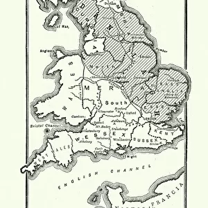
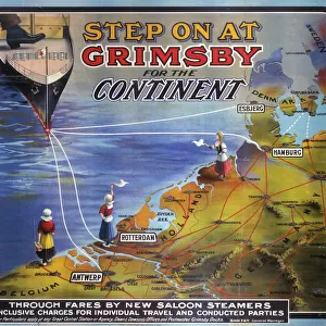
Photo Mug : Map of England Showing the Anglo-Saxon Kingdoms and Danish Districts


![]()
Home Decor from Liszt Collection
Map of England Showing the Anglo-Saxon Kingdoms and Danish Districts
Liszt Collection of nineteenth-century engravings and images to browse and enjoy
Media ID 12978366
© Quint Lox Limited
Anglo Saxon Danish Districts Kingdoms Plan Showing
Large Photo Mug (15 oz)
Introducing the Media Storehouse Photo Mug featuring "Map of England Showing the Anglo-Saxon Kingdoms and Danish Districts" by 000031 from the Liszt Collection. This unique mug brings history to life as you enjoy your favorite beverage. The high-quality print showcases intricate details of the Anglo-Saxon kingdoms and Danish districts, transporting you back in time. Perfect for history enthusiasts, this mug is not only a practical addition to your daily routine but also a beautiful conversation starter. Embrace the past with every sip.
Elevate your coffee or tea experience with our premium white ceramic mug. Its wide, comfortable handle makes drinking easy, and you can rely on it to be both microwave and dishwasher safe. Sold in single units, preview may show both sides of the same mug so you can see how the picture wraps around.
Elevate your coffee or tea experience with our premium white ceramic mug. Its wide, comfortable handle makes drinking easy, and you can rely on it to be both microwave and dishwasher safe. Sold in single units, preview may show both sides of the same mug so you can see how the picture wraps around.
These are individually made so all sizes are approximate
FEATURES IN THESE COLLECTIONS
> Liszt Collection
> Engravings
> Nineteenth Century Engraving
> Europe
> Denmark
> Related Images
> Europe
> United Kingdom
> England
> Maps
> Maps and Charts
> Related Images
EDITORS COMMENTS
This nineteenth-century engraving titled "Map of England Showing the Anglo-Saxon Kingdoms and Danish Districts" takes us on a journey back in time to explore the rich history of England. The intricately detailed map showcases the various Anglo-Saxon kingdoms and Danish districts that once shaped the landscape of this ancient land. With its retro-styled vintage appeal, this engraved image is not only a testament to Victorian arts and culture but also an illustrative technique that transports us into a bygone era. The engravement technique used in creating this print adds depth and texture, enhancing our visual experience as we study each kingdom and district meticulously depicted on the map. The Map of England serves as both a plan and chart, allowing us to delve into historical narratives while appreciating its artistic value. It offers a glimpse into how boundaries were drawn during that period, shedding light on political dynamics between different regions. As we observe this piece from Liszt Collection's vast archives, we are reminded of the importance of preserving cultural heritage through art. This print invites us to reflect upon our roots, fostering an appreciation for history's role in shaping our present-day society. Whether you are an avid historian or simply captivated by vintage aesthetics, this enchanting depiction will undoubtedly spark curiosity about England's past and leave you yearning for more knowledge about these fascinating Anglo-Saxon kingdoms and Danish districts.
MADE IN THE USA
Safe Shipping with 30 Day Money Back Guarantee
FREE PERSONALISATION*
We are proud to offer a range of customisation features including Personalised Captions, Color Filters and Picture Zoom Tools
SECURE PAYMENTS
We happily accept a wide range of payment options so you can pay for the things you need in the way that is most convenient for you
* Options may vary by product and licensing agreement. Zoomed Pictures can be adjusted in the Cart.