Photo Mug > Arts > Photorealistic artworks > Detailed art pieces > Masterful detailing in art
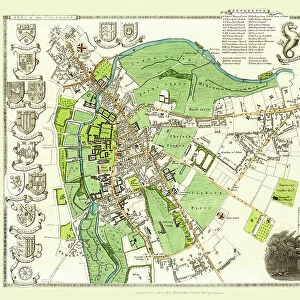
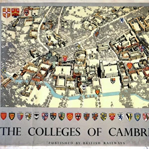
Photo Mug : Old Map of Cambridge 1804 by Cole and Roper


![]()
Home Decor from MapSeeker
Old Map of Cambridge 1804 by Cole and Roper
An attractive and detailed early 19th century reproduction town plan of Cambridge 1804. First published by Cole and Roper as a finely engraved series of county maps and town plans which were initially issued in parts and then together as The British Atlas in 1810
Welcome to the Mapseeker Image library and enter an historic gateway to one of the largest on-line collections of Historic Maps, Nostalgic Views, Vista's and Panorama's from a World gone by.
Media ID 20348096
© Mapseeker Publishing Ltd
Cole And Roper Historic Map Old Town Plan Town Plan Cambridge Cambridge City
Large Photo Mug (15 oz)
Add a touch of history to your daily routine with our Media Storehouse Old Map of Cambridge 1804 Photo Mug. This beautifully designed mug showcases an intricately detailed reproduction of the early 19th century town plan of Cambridge, first published by Cole and Roper. The Old Map of Cambridge 1804, sourced from MapSeeker, is vividly printed on one side of the mug, transporting you back in time. Perfect for tea or coffee, this sturdy mug is not only a functional addition to your kitchen but also a unique and thoughtful gift for history enthusiasts and Cambridge locals. Embrace the charm of the past with every sip.
Elevate your coffee or tea experience with our premium white ceramic mug. Its wide, comfortable handle makes drinking easy, and you can rely on it to be both microwave and dishwasher safe. Sold in single units, preview may show both sides of the same mug so you can see how the picture wraps around.
Elevate your coffee or tea experience with our premium white ceramic mug. Its wide, comfortable handle makes drinking easy, and you can rely on it to be both microwave and dishwasher safe. Sold in single units, preview may show both sides of the same mug so you can see how the picture wraps around.
These are individually made so all sizes are approximate
FEATURES IN THESE COLLECTIONS
> MapSeeker
> British Town And City Plans
> English & Welsh PORTFOLIO
> Arts
> Photorealistic artworks
> Detailed art pieces
> Masterful detailing in art
> Maps and Charts
> Early Maps
EDITORS COMMENTS
This print showcases an exquisite and meticulously detailed reproduction of the "Old Map of Cambridge 1804" by Cole and Roper. Dating back to the early 19th century, this town plan offers a fascinating glimpse into the historical landscape of Cambridge during that era. Originally published as part of a series of county maps and town plans, Cole and Roper's work stands out for its exceptional engraving technique and attention to detail. The map was initially released in parts before being consolidated into "The British Atlas" in 1810. As you explore this old map, you will be transported back in time to witness the evolution of Cambridge. Every street, building, and landmark is intricately depicted, allowing you to trace the city's development over two centuries ago. From bustling marketplaces to serene college courtyards, this historic map captures the essence of Cambridge's rich heritage. Whether you are a history enthusiast or simply appreciate fine craftsmanship, this print is sure to captivate your imagination. Hang it on your wall or display it proudly on your desk – let it serve as a reminder that even amidst modernity, echoes from our past continue to shape our present-day experiences in this remarkable city called Cambridge.
MADE IN THE USA
Safe Shipping with 30 Day Money Back Guarantee
FREE PERSONALISATION*
We are proud to offer a range of customisation features including Personalised Captions, Color Filters and Picture Zoom Tools
SECURE PAYMENTS
We happily accept a wide range of payment options so you can pay for the things you need in the way that is most convenient for you
* Options may vary by product and licensing agreement. Zoomed Pictures can be adjusted in the Cart.