Photo Mug > Europe > United Kingdom > England > Manchester > Manchester
Photo Mug : Old Map of Manchester and its Environs 1824 by William Swire


![]()
Home Decor from MapSeeker
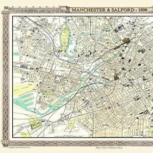
Old Map of Manchester and its Environs 1824 by William Swire
J128
Welcome to the Mapseeker Image library and enter an historic gateway to one of the largest on-line collections of Historic Maps, Nostalgic Views, Vista's and Panorama's from a World gone by.
Media ID 20347202
Historic Map Old Town Plan Manchester Manchester City
Large Photo Mug (15 oz)
Add a touch of history to your daily routine with our Media Storehouse Photo Mug featuring an Old Map of Manchester and its Environs from 1824, beautifully reproduced from the original map by William Swire from MapSeeker (J128). This high-quality mug not only keeps your beverages warm but also showcases the rich history of Manchester, making it a unique and thoughtful gift for any occasion. Embrace the past while enjoying your favorite drink.
Elevate your coffee or tea experience with our premium white ceramic mug. Its wide, comfortable handle makes drinking easy, and you can rely on it to be both microwave and dishwasher safe. Sold in single units, preview may show both sides of the same mug so you can see how the picture wraps around.
Elevate your coffee or tea experience with our premium white ceramic mug. Its wide, comfortable handle makes drinking easy, and you can rely on it to be both microwave and dishwasher safe. Sold in single units, preview may show both sides of the same mug so you can see how the picture wraps around.
These are individually made so all sizes are approximate
FEATURES IN THESE COLLECTIONS
> MapSeeker
> British Town And City Plans
> English & Welsh PORTFOLIO
> Europe
> United Kingdom
> England
> Manchester
> Manchester
> Maps and Charts
> Related Images
EDITORS COMMENTS
This print showcases the "Old Map of Manchester and its Environs 1824" by William Swire (J128), offering a fascinating glimpse into the rich history of this iconic city. Dating back to nearly two centuries ago, this meticulously detailed map provides an invaluable resource for those interested in exploring Manchester's past. The map encompasses not only the city itself but also its surrounding areas, presenting a comprehensive view of Manchester's development during that era. With intricate illustrations and precise cartographic techniques, it highlights key landmarks, streets, rivers, and even smaller details like parks and gardens. This visual representation allows us to trace the evolution of Manchester from its humble beginnings as a small town to becoming one of Britain's most influential industrial centers. As we delve into this historic treasure trove, we can almost imagine ourselves stepping back in time to witness bustling markets, horse-drawn carriages navigating narrow streets, and grand architectural marvels that have shaped the cityscape we know today. It serves as a reminder of how much has changed over the years while preserving our connection with Manchester's vibrant heritage. Whether you are an avid historian or simply curious about your hometown's roots, this old map offers endless opportunities for exploration and discovery. Its artistic charm combined with historical significance makes it a perfect addition to any collection or display dedicated to celebrating Manchester's remarkable journey through time.
MADE IN THE USA
Safe Shipping with 30 Day Money Back Guarantee
FREE PERSONALISATION*
We are proud to offer a range of customisation features including Personalised Captions, Color Filters and Picture Zoom Tools
SECURE PAYMENTS
We happily accept a wide range of payment options so you can pay for the things you need in the way that is most convenient for you
* Options may vary by product and licensing agreement. Zoomed Pictures can be adjusted in the Cart.