Photo Mug > MapSeeker > British Town And City Plans > English & Welsh PORTFOLIO
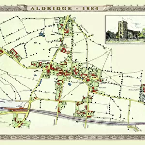
Photo Mug : Old Map of the Village of Pelsall near Walsall 1884


![]()
Home Decor from MapSeeker
Old Map of the Village of Pelsall near Walsall 1884
PL010
Welcome to the Mapseeker Image library and enter an historic gateway to one of the largest on-line collections of Historic Maps, Nostalgic Views, Vista's and Panorama's from a World gone by.
Media ID 20348229
Large Photo Mug (15 oz)
"Bring a piece of history to your morning routine with our Media Storehouse Photo Mug featuring an old map of Pelsall Village near Walsall, dating back to 1884. This high-quality mug showcases the intricate details of the MapSeeker PL010 Old Map of Pelsall, making every sip an adventure. Perfect for tea or coffee, this sturdy mug is microwave and dishwasher safe, ensuring convenience and durability. Relive the charm of the past with each use, as you enjoy your favorite beverage from this unique and personalized mug."
Elevate your coffee or tea experience with our premium white ceramic mug. Its wide, comfortable handle makes drinking easy, and you can rely on it to be both microwave and dishwasher safe. Sold in single units, preview may show both sides of the same mug so you can see how the picture wraps around.
Elevate your coffee or tea experience with our premium white ceramic mug. Its wide, comfortable handle makes drinking easy, and you can rely on it to be both microwave and dishwasher safe. Sold in single units, preview may show both sides of the same mug so you can see how the picture wraps around.
These are individually made so all sizes are approximate
EDITORS COMMENTS
This print showcases an exquisite piece of history, the "Old Map of the Village of Pelsall near Walsall 1884". Stepping back in time, this historic map offers a glimpse into the past, allowing us to explore and appreciate the village of Pelsall as it stood over a century ago. With intricate details and delicate craftsmanship, this map transports us to a bygone era. Every street, building, and landmark is meticulously depicted, providing an invaluable resource for those interested in tracing their roots or studying local history. The village of Pelsall comes alive through this vintage cartographic gem. As we delve into its faded lines and faded hues, we can almost hear echoes from the past whispering stories about life in this quaint English village. From bustling marketplaces to charming cottages nestled amidst lush greenery, every corner holds tales waiting to be discovered. Whether you are a history enthusiast or simply captivated by the beauty of old maps, this print serves as a cherished keepsake that connects us with our heritage. It invites us on an enchanting journey through time while honoring the legacy of Pelsall's vibrant community. Displaying this remarkable piece will not only add character to any space but also spark conversations about our shared past. Let yourself be transported back to 1884 as you immerse yourself in the rich tapestry woven within these ancient streets and alleys captured forever on this extraordinary map print.
MADE IN THE USA
Safe Shipping with 30 Day Money Back Guarantee
FREE PERSONALISATION*
We are proud to offer a range of customisation features including Personalised Captions, Color Filters and Picture Zoom Tools
SECURE PAYMENTS
We happily accept a wide range of payment options so you can pay for the things you need in the way that is most convenient for you
* Options may vary by product and licensing agreement. Zoomed Pictures can be adjusted in the Cart.