Photo Mug > Arts > Artists > S > John Speed
Photo Mug : Old County Map of Derbyshire 1611 by John Speed


Home Decor from MapSeeker
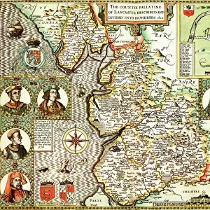
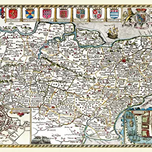
Old County Map of Derbyshire 1611 by John Speed
A facimile of John Speeds historical map of Derbyshire originally published for the " Theatre of the Empire of Great Britain", an atlas to accompany " a history of Great Britain"
Welcome to the Mapseeker Image library and enter an historic gateway to one of the largest on-line collections of Historic Maps, Nostalgic Views, Vista's and Panorama's from a World gone by.
Media ID 20347969
© Mapseeker Publishing Ltd
County Map County Map Of England English County Map Historic Map John Speed Map Old County Map Old English County Map Speed Map Speede Map Derbyshire
Photo Mug (11 oz)
Introducing the Media Storehouse Photo Mug featuring an old county map of Derbyshire, dated 1611. This beautiful mug showcases a captivating replica of the historical map by renowned cartographer John Speed, published originally in his "Theatre of the Empire of Great Britain" atlas. Bring a piece of history into your daily routine as you enjoy your favorite beverage from this stylish and functional mug. Perfect for history enthusiasts, map collectors, or anyone who appreciates the beauty of vintage cartography. Sip and reminisce as you trace the contours of Derbyshire's landscape as it appeared over 400 years ago.
A personalized photo mug blends sentimentality with functionality, making an ideal gift for cherished loved ones, close friends, or valued colleagues. Preview may show both sides of the same mug.
Elevate your coffee or tea experience with our premium white ceramic mug. Its wide, comfortable handle makes drinking easy, and you can rely on it to be both microwave and dishwasher safe. Sold in single units, preview may show both sides of the same mug so you can see how the picture wraps around.
Mug Size is 8cm high x 9.5cm diameter (3.1" x 3.7")
These are individually made so all sizes are approximate
FEATURES IN THESE COLLECTIONS
> MapSeeker
> Maps from the British Isles
> England and Counties PORTFOLIO
> Arts
> Artists
> S
> John Speed
> Europe
> United Kingdom
> England
> Derbyshire
> Related Images
> Europe
> United Kingdom
> England
> Maps
> Maps and Charts
> British Empire Maps
> Maps and Charts
> Early Maps
> Maps and Charts
> Related Images
EDITORS COMMENTS
Step back in time with this exquisite print of the 'Old County Map of Derbyshire 1611' by John Speed. A true testament to the rich history and intricate craftsmanship, this facsimile captures every detail of Speed's original masterpiece. Originally published as part of his renowned atlas, 'The Theatre of the Empire of Great Britain', this map was created to accompany a comprehensive history of Great Britain. It offers a fascinating glimpse into the past, showcasing the boundaries and landmarks that shaped Derbyshire during the early 17th century. With its elegant calligraphy and beautifully illustrated cartouches, this old English county map is a treasure trove for historians, geography enthusiasts, or anyone captivated by England's heritage. The meticulous attention to detail transports you back in time as you explore each village, river, and hill depicted on this historical gem. Derbyshire comes alive through Speed's expert handiwork – from bustling market towns like Derby itself to picturesque landscapes dotted with ancient castles and manor houses. This print allows you to trace your ancestors' footsteps or simply marvel at how much has changed over centuries while appreciating what remains unchanged. Whether adorning your study wall or serving as an educational tool in classrooms or libraries, this authentic reproduction brings both beauty and knowledge into any space. Immerse yourself in Derbyshire's past with this remarkable piece – a must-have for any lover of maps or British history.
MADE IN THE USA
Safe Shipping with 30 Day Money Back Guarantee
FREE PERSONALISATION*
We are proud to offer a range of customisation features including Personalised Captions, Color Filters and Picture Zoom Tools
SECURE PAYMENTS
We happily accept a wide range of payment options so you can pay for the things you need in the way that is most convenient for you
* Options may vary by product and licensing agreement. Zoomed Pictures can be adjusted in the Cart.