Photo Mug > Europe > United Kingdom > Scotland > Clackmannanshire > Clackmannan
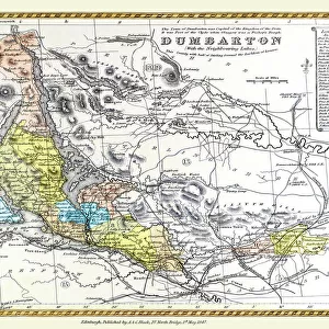
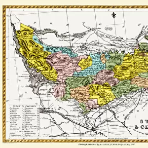
Photo Mug : Old County Map of Stirling and Clackmannan Scotland 1847 by A&C Black


![]()
Home Decor from MapSeeker
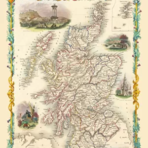
Old County Map of Stirling and Clackmannan Scotland 1847 by A&C Black
A finely detailed facimile remastered in full colour from an antique original map of Stirling and Clackmannan featured in A&C Blacks Atlas of 1847. Each Parish is numbered using an index table, colour rendition beautifully differentiating all of the Parishes. As well as principal roads, towns, villages and hamlets, these county maps of Scotland feature key battle sites marked with two crossed swords and the date of the battle
Welcome to the Mapseeker Image library and enter an historic gateway to one of the largest on-line collections of Historic Maps, Nostalgic Views, Vista's and Panorama's from a World gone by.
Media ID 20347610
© Mapseeker Publishing Ltd
A And C Black A And C Black Atlas A And C Black Map County Map County Map Of Scotland Historic Map Old County Map Old Scottish County Map Scottish County Map Clackmannan Clackmannanshire Stirling Stirlingshire
Large Photo Mug (15 oz)
Add a touch of history to your daily routine with our Media Storehouse Photo Mug featuring a finely detailed, full-color facsimile of the Old County Map of Stirling and Clackmannan, Scotland 1847 by A&C Black from MapSeeker. This antique map, originally featured in A&C Black's Atlas of 1847, showcases the rich history and intricate details of the region. Each mug holds your favorite beverage while providing a captivating display of this beautifully remastered map. Perfect for history enthusiasts, map collectors, or anyone who appreciates the charm of the past. Embrace the nostalgia and enjoy your morning coffee or evening tea with a piece of Scotland's history in your hands.
Elevate your coffee or tea experience with our premium white ceramic mug. Its wide, comfortable handle makes drinking easy, and you can rely on it to be both microwave and dishwasher safe. Sold in single units, preview may show both sides of the same mug so you can see how the picture wraps around.
Elevate your coffee or tea experience with our premium white ceramic mug. Its wide, comfortable handle makes drinking easy, and you can rely on it to be both microwave and dishwasher safe. Sold in single units, preview may show both sides of the same mug so you can see how the picture wraps around.
These are individually made so all sizes are approximate
FEATURES IN THESE COLLECTIONS
> MapSeeker
> Maps from the British Isles
> Scotland and Counties PORTFOLIO
> Arts
> Photorealistic artworks
> Detailed art pieces
> Masterful detailing in art
> Europe
> United Kingdom
> Scotland
> Clackmannanshire
> Clackmannan
> Europe
> United Kingdom
> Scotland
> Clackmannanshire
> Related Images
> Europe
> United Kingdom
> Scotland
> Maps
> Europe
> United Kingdom
> Scotland
> Stirling
> Europe
> United Kingdom
> Scotland
> Stirlingshire
> Related Images
> Europe
> United Kingdom
> Scotland
> Stirlingshire
> Stirling
> Historic
> Battles
> Related Images
> Maps and Charts
> Early Maps
> Maps and Charts
> Related Images
EDITORS COMMENTS
This beautifully crafted print showcases an Old County Map of Stirling and Clackmannan, Scotland from 1847. Remastered in full color from an antique original map featured in A&C Black's Atlas, this finely detailed facsimile captures the essence of a bygone era. The map is not only visually stunning but also highly informative. Each Parish is numbered using an index table, allowing for easy navigation and reference. The color rendition skillfully differentiates all of the Parishes, bringing them to life on the page. In addition to highlighting principal roads, towns, villages, and hamlets, this historic map goes above and beyond by marking key battle sites with two crossed swords and their respective dates. This feature adds a layer of historical significance to the already captivating visual representation. Whether you are a history enthusiast or simply appreciate the beauty of cartography, this old Scottish county map is sure to captivate your imagination. It provides a fascinating glimpse into the past while offering valuable insights into the geography and history of Stirling and Clackmannan. Perfect for framing or displaying as part of a collection, this print preserves both the aesthetic charm and historical importance of this remarkable piece. Whether it adorns your home or office walls, it will undoubtedly spark conversations about Scotland's rich heritage and its ever-evolving landscape throughout time.
MADE IN THE USA
Safe Shipping with 30 Day Money Back Guarantee
FREE PERSONALISATION*
We are proud to offer a range of customisation features including Personalised Captions, Color Filters and Picture Zoom Tools
SECURE PAYMENTS
We happily accept a wide range of payment options so you can pay for the things you need in the way that is most convenient for you
* Options may vary by product and licensing agreement. Zoomed Pictures can be adjusted in the Cart.