Photo Mug > Maps and Charts > Early Maps
Photo Mug : Crusades Map


Home Decor from Mary Evans Picture Library
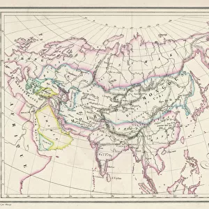
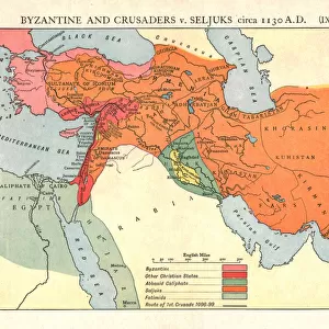
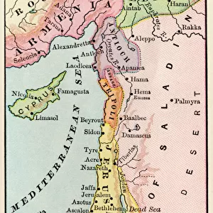
Crusades Map
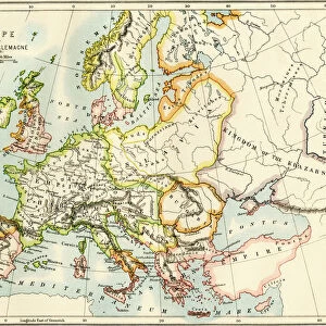
A map of Europe depicting the paths of various Crusades between 1096 and 1270
Mary Evans Picture Library makes available wonderful images created for people to enjoy over the centuries
Media ID 4344715
© Mary Evans Picture Library 2015 - https://copyrighthub.org/s0/hub1/creation/maryevans/MaryEvansPictureID/10139291
1096 1270 Crusades Depicting Paths
Large Photo Mug (15 oz)
Introducing the Media Storehouse Photo Mug, a unique and thoughtful gift that lets you carry your favorite images with you everywhere you go. This mug features a captivating Crusades Map, taken from the extensive collection of Mary Evans Prints Online. Relive history with every sip as you explore the paths of the Crusades, spanning from 1096 to 1270. The high-quality print ensures vibrant colors and long-lasting durability. Perfect for history enthusiasts, travelers, or anyone who appreciates the beauty of maps, this mug is sure to become a cherished addition to any collection. Order yours today and embark on a journey through time, one sip at a time.
Elevate your coffee or tea experience with our premium white ceramic mug. Its wide, comfortable handle makes drinking easy, and you can rely on it to be both microwave and dishwasher safe. Sold in single units, preview may show both sides of the same mug so you can see how the picture wraps around.
Elevate your coffee or tea experience with our premium white ceramic mug. Its wide, comfortable handle makes drinking easy, and you can rely on it to be both microwave and dishwasher safe. Sold in single units, preview may show both sides of the same mug so you can see how the picture wraps around.
These are individually made so all sizes are approximate
FEATURES IN THESE COLLECTIONS
> Europe
> Related Images
> Maps and Charts
> Early Maps
> Maps and Charts
> Related Images
> Popular Themes
> Maps and Charts
EDITORS COMMENTS
This striking print captures a detailed and historically significant Crusades Map, showcasing the paths of various Crusades that took place between 1096 and 1270 across Europe. The intricate design of the map allows viewers to trace the movements of armies, battles, and key events that shaped this tumultuous period in history.
The Crusades were a series of religious wars sanctioned by the Latin Church in the medieval period, with the goal of reclaiming Jerusalem and other holy sites from Muslim rule. This map provides a visual representation of how these military campaigns unfolded over several centuries, highlighting the strategic routes taken by crusaders as they journeyed through different regions of Europe.
From major cities to important landmarks, each detail on this map offers valuable insights into the political dynamics and cultural exchanges that occurred during this time. By studying the paths depicted on this historical artifact, one can gain a deeper understanding of how these conflicts impacted societies across Europe and beyond.
Whether you are a history enthusiast or simply intrigued by ancient warfare, this image is sure to spark curiosity and prompt reflection on the lasting legacy of the Crusades. It serves as a powerful reminder of how past events continue to shape our present-day world.
MADE IN THE USA
Safe Shipping with 30 Day Money Back Guarantee
FREE PERSONALISATION*
We are proud to offer a range of customisation features including Personalised Captions, Color Filters and Picture Zoom Tools
SECURE PAYMENTS
We happily accept a wide range of payment options so you can pay for the things you need in the way that is most convenient for you
* Options may vary by product and licensing agreement. Zoomed Pictures can be adjusted in the Cart.