Photo Mug > Europe > France > Maps
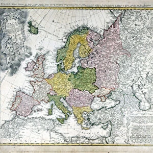
Photo Mug : Map / Europe / Germany 1880S


![]()
Home Decor from Mary Evans Picture Library
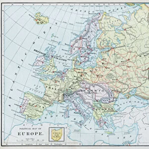
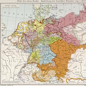
Map / Europe / Germany 1880S
Map of the German Empire (southern part) after the war with France, including Alsace and Lorraine
Mary Evans Picture Library makes available wonderful images created for people to enjoy over the centuries
Media ID 4357663
© Mary Evans Picture Library 2015 - https://copyrighthub.org/s0/hub1/creation/maryevans/MaryEvansPictureID/10114038
Alsace Including Lorraine Maps Southern
Large Photo Mug (15 oz)
"Add a touch of history to your daily routine with our Media Storehouse Photo Mugs. Featuring an intriguing map of Germany from the 1880s, this mug showcases the German Empire's southern region, including Alsace and Lorraine, after the war with France. This high-quality mug is not only a functional and stylish addition to your kitchen but also a unique conversation starter. The vibrant image is digitally printed on both sides, ensuring a clear and crisp representation of the map from Mary Evans Prints Online. Perfect for history enthusiasts, travelers, or anyone who appreciates the beauty of old maps, this Photo Mug is a must-have in your collection. Embrace the past with every sip."
Elevate your coffee or tea experience with our premium white ceramic mug. Its wide, comfortable handle makes drinking easy, and you can rely on it to be both microwave and dishwasher safe. Sold in single units, preview may show both sides of the same mug so you can see how the picture wraps around.
Elevate your coffee or tea experience with our premium white ceramic mug. Its wide, comfortable handle makes drinking easy, and you can rely on it to be both microwave and dishwasher safe. Sold in single units, preview may show both sides of the same mug so you can see how the picture wraps around.
These are individually made so all sizes are approximate
FEATURES IN THESE COLLECTIONS
> Maps and Charts
> Early Maps
> Maps and Charts
> Related Images
EDITORS COMMENTS
This vintage map print showcases the southern part of the German Empire in the 1880s, following the war with France. The detailed cartography includes regions such as Alsace and Lorraine, which were hotly contested territories during this period of history. The map provides a fascinating glimpse into Europe's political landscape at a time when borders were constantly shifting.
The intricate design and historical significance of this map make it a captivating piece for any history enthusiast or collector. It serves as a reminder of the complex relationships between nations and the ever-changing nature of geopolitics.
With its muted color palette and intricate details, this map exudes an old-world charm that is sure to add character to any space. Whether displayed in a study, library, or living room, this print is bound to spark conversations about European history and the legacy of past conflicts.
Overall, this map print from Mary Evans Prints Online is not just a decorative piece but also a valuable historical artifact that offers insight into Germany's territorial expansion and geopolitical ambitions in the late 19th century. A must-have for anyone interested in European history or cartography.
MADE IN THE USA
Safe Shipping with 30 Day Money Back Guarantee
FREE PERSONALISATION*
We are proud to offer a range of customisation features including Personalised Captions, Color Filters and Picture Zoom Tools
SECURE PAYMENTS
We happily accept a wide range of payment options so you can pay for the things you need in the way that is most convenient for you
* Options may vary by product and licensing agreement. Zoomed Pictures can be adjusted in the Cart.