Photo Mug > Europe > United Kingdom > England > London > Sport > Sailing
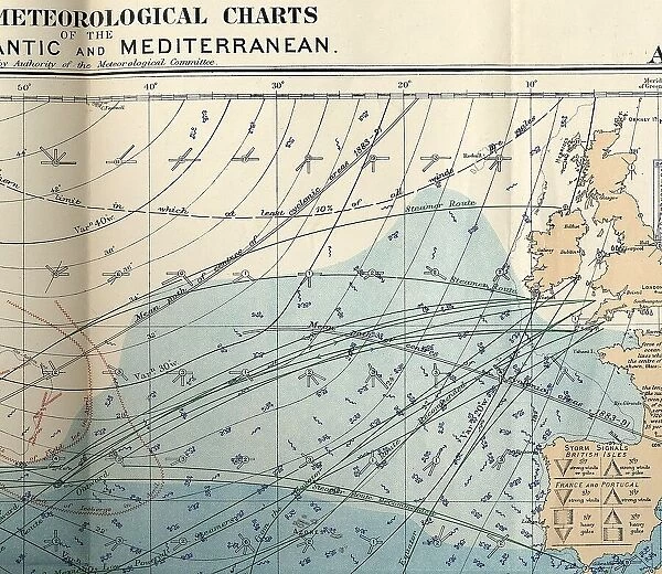
Photo Mug : RMS Titanic - shipping chart of North Atlantic
![]()

Home Decor from Mary Evans Picture Library
RMS Titanic - shipping chart of North Atlantic
RMS Titanic - shipping chart of North Atlantic for the month of April 1912, Sheet 133, Meteorological Office, London. The chart is in colour and displays wind, sea current, sea temperature, limits of field ice, limits of icebergs, wireless telegraphy stations, submarine signal stations, magnetic variation, routes for sailing vessels, steamships, and low-powered steamships, and great circle routes. The reverse has several smaller charts displaying air pressure for March (with names of reporting ships) and sea and air temperatures for February. Also notes on sea temperature, sea ice, Arctic ice in 1911, and derelict ships (floating wooden hulks). A similar chart would have been available to the Titanic and ships travelling the North Atlantic in April 1912. Date: 1912
Mary Evans Picture Library makes available wonderful images created for people to enjoy over the centuries
Media ID 32253594
© Henry Aldridge & Son Ltd. / Mary Evans
Arctic Atlantic Chart Charts Circle Current Derelict Displaying Displays Floating Hazards Hulks Icebergs Isles Limits Magnetic Main Mediterranean Meteorological Month Names Navigation Notes Office Pressure Reporting Reverse Routes Sheet Shipping Signal Similar Smaller Stations Steamships Submarine Telegraphy Temperature Temperatures Titanic Travelling Variation Vessels Wind Wireless Liner
Large Photo Mug (15 oz)
Add a piece of maritime history to your daily routine with our Media Storehouse Photo Mug featuring the RMS Titanic's North Atlantic Shipping Chart from Henry Aldridge & Son Ltd. This vintage chart, sourced from Mary Evans Prints Online, displays meteorological information for the month of April 1912, providing a captivating glimpse into the weather conditions of the infamous voyage. With intricate details of wind patterns, sea currents, and sea temperatures, this mug is not just a functional drinkware but a conversation starter and a collector's item. Embrace the allure of the sea and relive history with every sip.
Elevate your coffee or tea experience with our premium white ceramic mug. Its wide, comfortable handle makes drinking easy, and you can rely on it to be both microwave and dishwasher safe. Sold in single units, preview may show both sides of the same mug so you can see how the picture wraps around.
Elevate your coffee or tea experience with our premium white ceramic mug. Its wide, comfortable handle makes drinking easy, and you can rely on it to be both microwave and dishwasher safe. Sold in single units, preview may show both sides of the same mug so you can see how the picture wraps around.
These are individually made so all sizes are approximate
FEATURES IN THESE COLLECTIONS
> Mary Evans Prints Online
> New Images July 2023
> Arts
> Artists
> O
> Oceanic Oceanic
> Europe
> France
> Sport
> Sailing
> Europe
> Spain
> Related Images
> Europe
> United Kingdom
> England
> London
> Related Images
> Europe
> United Kingdom
> England
> London
> Sport
> Sailing
> Maps and Charts
> Related Images
EDITORS COMMENTS
This print showcases the RMS Titanic's shipping chart of the North Atlantic for the month of April 1912, issued by the Meteorological Office in London. The intricately detailed, color chart is a snapshot of the maritime world during a pivotal period in shipping history. The chart displays essential information for navigating the North Atlantic, including wind patterns, sea currents, temperature readings, limits of field ice and icebergs, wireless telegraphy stations, submarine signal stations, magnetic variation, and various routes for sailing vessels, steamships, and low-powered steamships. The reverse of the chart reveals smaller charts, depicting air pressure for March and sea and air temperatures for February. Notable annotations include sea temperature readings, sea ice conditions, Arctic ice coverage in 1911, and derelict ships, such as floating wooden hulks. This chart would have been an indispensable tool for the Titanic and other ships traversing the North Atlantic during this time. The chart also highlights the interconnectedness of shipping routes between the British Isles, France, and Spain, as well as the Mediterranean Sea. The intricate design and wealth of information convey the importance of precise navigation and the significant role of meteorological offices in ensuring the safety of maritime travel during the early 1900s. This stunning, vintage print is a testament to the rich history of maritime transportation and the intricacies of navigating the North Atlantic during the Titanic era.
MADE IN THE USA
Safe Shipping with 30 Day Money Back Guarantee
FREE PERSONALISATION*
We are proud to offer a range of customisation features including Personalised Captions, Color Filters and Picture Zoom Tools
SECURE PAYMENTS
We happily accept a wide range of payment options so you can pay for the things you need in the way that is most convenient for you
* Options may vary by product and licensing agreement. Zoomed Pictures can be adjusted in the Cart.


