Photo Mug > Africa > South Africa > Maps
Photo Mug : Map of Cape Colony, South Africa


Home Decor from North Wind
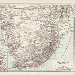
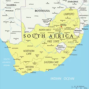
Map of Cape Colony, South Africa
South Africa when a British colony, 1870s.
Printed color lithograph of a 19th-century illustration
North Wind Picture Archives brings history to life with stock images and hand-colored illustrations
Media ID 5876533
© North Wind Picture Archives
Africa African British British Colony British Empire Colonial Colony South Africa South African Cape Colony Cape Of Good Hope
Large Photo Mug (15 oz)
Bring a piece of history to your morning routine with our Media Storehouse Photo Mug featuring a stunning, vintage Map of Cape Colony from the North Wind Picture Archives. This captivating 1870s illustration, showcasing South Africa during its time as a British colony, is sure to add character and intrigue to your daily cup of coffee or tea. Each mug is expertly printed in vibrant color to bring out the rich details of this historical map, making it a unique and thoughtful gift for history enthusiasts or anyone who appreciates the beauty of the past. Embrace the stories that lie within each sip from this beautifully designed mug.
Elevate your coffee or tea experience with our premium white ceramic mug. Its wide, comfortable handle makes drinking easy, and you can rely on it to be both microwave and dishwasher safe. Sold in single units, preview may show both sides of the same mug so you can see how the picture wraps around.
Elevate your coffee or tea experience with our premium white ceramic mug. Its wide, comfortable handle makes drinking easy, and you can rely on it to be both microwave and dishwasher safe. Sold in single units, preview may show both sides of the same mug so you can see how the picture wraps around.
These are individually made so all sizes are approximate
FEATURES IN THESE COLLECTIONS
> North Wind Picture Archives
> Africa history
> North Wind Picture Archives
> Maps
> Africa
> Related Images
> Africa
> South Africa
> Maps
> Africa
> South Africa
> Related Images
> Historic
> Colonial history
> Colonial art and artists
> Maps and Charts
> British Empire Maps
> Maps and Charts
> Related Images
EDITORS COMMENTS
This vintage print showcases a meticulously detailed "Map of Cape Colony, South Africa" during the 1870s when it was under British colonial rule. The printed color lithograph beautifully captures the essence of this historic era, transporting us back to a time when South Africa's destiny was being shaped by external forces. The map itself is an exquisite piece of art that not only serves as a visual representation but also tells the story of African heritage and tradition intertwined with colonial history. It highlights the vastness and diversity of this magnificent land, from its breathtaking landscapes to its vibrant cities. As we gaze upon this artwork, we are reminded of the significant role played by the British Empire in shaping South Africa's trajectory during the 19th century. The Cape Colony, located at the southern tip known as Cape of Good Hope, emerges as a focal point on this map - symbolizing both opportunity and struggle for those who inhabited these lands. This print from North Wind Picture Archives allows us to delve into history and explore how different cultures collided and coexisted within South Africa's borders. It serves as a reminder that understanding our past is crucial in appreciating our present and building a better future
MADE IN THE USA
Safe Shipping with 30 Day Money Back Guarantee
FREE PERSONALISATION*
We are proud to offer a range of customisation features including Personalised Captions, Color Filters and Picture Zoom Tools
SECURE PAYMENTS
We happily accept a wide range of payment options so you can pay for the things you need in the way that is most convenient for you
* Options may vary by product and licensing agreement. Zoomed Pictures can be adjusted in the Cart.