Photo Mug > North America > United States of America > New York > New York > Maps
Photo Mug : Manhattan map, 1780s


![]()
Home Decor from North Wind
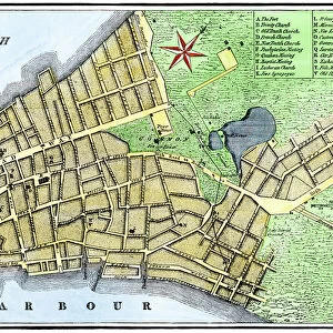
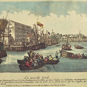
Manhattan map, 1780s
John Hills map of New York City, surveyed in 1782, drawn in 1785.
Hand-colored woodcut reproduction of an 18th-century illustration
North Wind Picture Archives brings history to life with stock images and hand-colored illustrations
Media ID 5882555
© North Wind Picture Archives
1700s 1780s 18th Century Chart Harbor Manhattan New York New York City John Hill
Large Photo Mug (15 oz)
"Step back in time with our vintage Manhattan Map Photo Mug from Media Storehouse. Featuring a captivating 1780s illustration of New York City from the North Wind Picture Archives, this mug showcases a hand-colored woodcut reproduction of John Hills' 1782 survey map, drawn in 1785. Perfect for history enthusiasts or anyone who appreciates the charm of old maps, this mug is not only a functional and stylish addition to your daily routine but also a fascinating conversation starter. Immerse yourself in the history of one of the world's most iconic cities as you enjoy your favorite beverage. Cheers to the past!"
Elevate your coffee or tea experience with our premium white ceramic mug. Its wide, comfortable handle makes drinking easy, and you can rely on it to be both microwave and dishwasher safe. Sold in single units, preview may show both sides of the same mug so you can see how the picture wraps around.
Elevate your coffee or tea experience with our premium white ceramic mug. Its wide, comfortable handle makes drinking easy, and you can rely on it to be both microwave and dishwasher safe. Sold in single units, preview may show both sides of the same mug so you can see how the picture wraps around.
These are individually made so all sizes are approximate
FEATURES IN THESE COLLECTIONS
> North Wind Picture Archives
> Maps
> North Wind Picture Archives
> New York City
> Arts
> Artists
> H
> John Hillers
> Arts
> Artists
> H
> John Hills
> North America
> United States of America
> New York
> New York
> Manhattan
> Related Images
> North America
> United States of America
> New York
> New York
> Maps
> North America
> United States of America
> New York
> Related Images
EDITORS COMMENTS
This print showcases a remarkable piece of history - the Manhattan map from the 1780s. Created by John Hills, this map was meticulously surveyed in 1782 and beautifully drawn in 1785. The hand-colored woodcut reproduction perfectly captures the essence of this 18th-century illustration. Transport yourself back to a time when New York City was still emerging as a bustling metropolis. This vintage depiction exudes an air of heritage and tradition, taking you on a visual journey through the city's historic roots. Every detail is carefully etched onto the paper, allowing you to explore the intricate streets and landmarks that shaped Manhattan during its early years. Marvel at how different things were back then as you trace your finger along this chart-like masterpiece. From the vibrant harbor teeming with ships to the quaint neighborhoods that have since transformed into iconic districts, this map offers an invaluable glimpse into New York City's past. As you gaze upon this artful representation, let your imagination wander through North America's history and envision what life was like in those early days of our great nation. The United States had just gained independence, and Manhattan played a vital role in shaping its future. Appreciate not only John Hill's artistic talent but also his contribution to preserving our collective memory. This print serves as a tangible reminder of where we came from and how far we've come. Let it inspire curiosity about our shared heritage while adding an elegant touch of historical charm to any space it graces.
MADE IN THE USA
Safe Shipping with 30 Day Money Back Guarantee
FREE PERSONALISATION*
We are proud to offer a range of customisation features including Personalised Captions, Color Filters and Picture Zoom Tools
SECURE PAYMENTS
We happily accept a wide range of payment options so you can pay for the things you need in the way that is most convenient for you
* Options may vary by product and licensing agreement. Zoomed Pictures can be adjusted in the Cart.