Photo Mug > Oceania > Australia > Maps
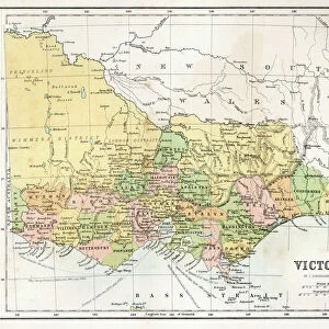
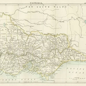
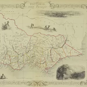
Photo Mug : Victoria province, Australia, 1800s


Home Decor from North Wind
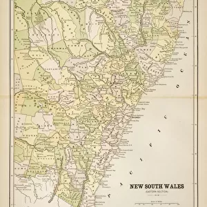
Victoria province, Australia, 1800s
Map of Victoria, Australia, 1870s.
Color lithograph reproduction of a 19th-century illustration
North Wind Picture Archives brings history to life with stock images and hand-colored illustrations
Media ID 5882627
© North Wind Picture Archives
Australia Australian British Empire
Large Photo Mug (15 oz)
Introducing the Media Storehouse Photo Mug, a perfect blend of history and functionality. Featuring an exquisite image from North Wind Picture Archives, this mug showcases a captivating view of Victoria province, Australia, during the 1800s. This stunning 19th-century illustration, a color lithograph reproduction of a map from 1870s, is sure to transport you back in time with every sip. Embrace the rich history of Australia while enjoying your favorite beverage in this high-quality, Microwave and dishwasher safe mug. Bring a piece of the past into your daily routine with the Media Storehouse Photo Mug.
Elevate your coffee or tea experience with our premium white ceramic mug. Its wide, comfortable handle makes drinking easy, and you can rely on it to be both microwave and dishwasher safe. Sold in single units, preview may show both sides of the same mug so you can see how the picture wraps around.
Elevate your coffee or tea experience with our premium white ceramic mug. Its wide, comfortable handle makes drinking easy, and you can rely on it to be both microwave and dishwasher safe. Sold in single units, preview may show both sides of the same mug so you can see how the picture wraps around.
These are individually made so all sizes are approximate
FEATURES IN THESE COLLECTIONS
> North Wind Picture Archives
> Maps
> Maps and Charts
> British Empire Maps
> Maps and Charts
> Related Images
> Oceania
> Australia
> Related Images
EDITORS COMMENTS
This print takes us back to the 1800s, offering a glimpse into the rich history of Victoria province in Australia. The map, dating back to the 1870s, showcases the intricate details and artistry of a color lithograph reproduction from that era. It is truly a testament to the craftsmanship and dedication of those who created it. The vintage charm exuded by this illustration transports us to a time when Australia was still under British rule, as part of their vast empire. The map serves as an invaluable historical artifact, shedding light on the traditional heritage and cultural significance of Victoria province. As we explore this piece further, we are reminded of how far Victoria has come since those early days. This print invites us to reflect on its evolution over time – from humble beginnings as an integral part of British colonial expansion in Australia's mainland to becoming one of today's most vibrant and thriving provinces. Whether you are an art enthusiast or a history buff, this print offers a unique opportunity for appreciation. Its presence allows us to connect with our past while appreciating the beauty embedded within this stunning representation
MADE IN THE USA
Safe Shipping with 30 Day Money Back Guarantee
FREE PERSONALISATION*
We are proud to offer a range of customisation features including Personalised Captions, Color Filters and Picture Zoom Tools
SECURE PAYMENTS
We happily accept a wide range of payment options so you can pay for the things you need in the way that is most convenient for you
* Options may vary by product and licensing agreement. Zoomed Pictures can be adjusted in the Cart.