Photo Mug > Sheffield City Archives > Maps and Plans > Sheffield OS maps
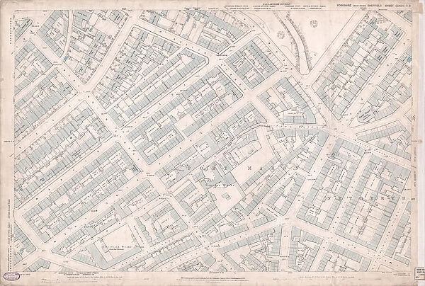
Photo Mug : Ordnance Survey Map, Sheffield, Netherthorpe area, 1889 (Yorkshire sheet 294. 7. 9)

Home Decor from Sheffield City Archives
Ordnance Survey Map, Sheffield, Netherthorpe area, 1889 (Yorkshire sheet 294. 7. 9)
This map features:
Top left: Abbey Street, Springvale Road, Crookesmoor Road, Burlington Street, Martin Street, Wentworth Street, Adelphi Street, Oxford Street, Martin Lane, Sunday School, Scarborough Hotel Public House, Upperthorpe House, Oak Villas, Burlington Villa, Craig Royston House, Brighton Villa, Carltonville, Shipton Street, Carlton House, Oxford Villa, Summerfield House, Wentworth Villa, Paragon Place, Elgin Villa, Ash Villa, Montrose Villa, Eton Ville, Gotha Villa, Olive Villa, Fern Villa, Myrtle Villa, Brunswick Terrace, Albion Terrace.
Top right: Wentworth Street, Montgomery Terrace Road, New Meadow Street, Adelphi Street, Upperthorpe Road, Watery Lane, St. Philips Road, Netherthorpe Place, Malinda Street, Port Mahon, Watery Street, [Charles Gray and Sons, Steel Manufacturers], St. Philips Works (steel), Wentworth Terrace, [Port Mahon Baptist Chapel], Baptist Chapel, Watery Street, Malinda Villa, Albert House, Adelaide House, Sussex House, West View, York Villa, Downing Lane, Wentworth House Public House.
Bottom left: Burlington Street, Martin Street, Wentworth Street, [Turton Brothers and Matthews, Steel Manufacturers], Phoenix Steel Works, Wentworth Street, Burlington Hotel Public House, [A. F. Callum and Co. Ivory Button Manufacturers], Neptune Works (Buttons), Bond Street, Fawcett Street, Morton Street, Bellefield Lane, Hammond Street, Bellefield Street, Burlington Terrace, Premier Works, sickles, scythes, machine knives, etc, [Tilghmans Patent Sand Blast Co Ltd.], Bellefield Works, Sand Blast Machinery, Fawcett Street, Bellefield Terrace, Featherstone Terrace, India Terrace, Mission Hall [St Philips Mission Room], Watery Lane.
Bottom right: Port Mahon, Hammond Street, Bellefield Street, Watery Lane, St. Philips Road, Netherthorpe Place, Ellison Street, Dover Street, Netherthorpe Street, Bethel Street, Hunt Street, [George Shaw Spring Knife Manufacturer], Cutlery Works, Clyde Place, Cross Hunt Street, St. Philips Tavern.
Dimensions of original: 77 x 102 cm.
Scale 10.56 feet : 1 mile [1:500].
From an original at Sheffield Libraries: q00053 (sheet No. 294.7.9)
Sheffield City Archives and Local Studies Library has an unrivalled collection of images of Sheffield, England
Media ID 25801023
© Sheffield City Council - All Rights Reserved
Old Map Os Map Sheffield Yorkshire
Large Photo Mug (15 oz)
Step back in time with our Media Storehouse Photo Mug, featuring an intriguing historical map of Sheffield's Netherthorpe area from 1889. This beautifully detailed Ordnance Survey Map, sourced from Sheffield City Archives, showcases the topography and street layout of the time, including Abbey Street, Springvale Road, Crookesmoor Road, Burlington Street, Martin Street, Wentworth Street, Adelphi Street, Oxford Street, Martin Lane, and Sunday School. Perfect for tea or coffee breaks, this sturdy mug is a unique and thoughtful gift for history enthusiasts and locals, allowing you to enjoy a piece of Sheffield's rich heritage with every sip.
Elevate your coffee or tea experience with our premium white ceramic mug. Its wide, comfortable handle makes drinking easy, and you can rely on it to be both microwave and dishwasher safe. Sold in single units, preview may show both sides of the same mug so you can see how the picture wraps around.
Elevate your coffee or tea experience with our premium white ceramic mug. Its wide, comfortable handle makes drinking easy, and you can rely on it to be both microwave and dishwasher safe. Sold in single units, preview may show both sides of the same mug so you can see how the picture wraps around.
These are individually made so all sizes are approximate
EDITORS COMMENTS
This print showcases an Ordnance Survey Map of the Netherthorpe area in Sheffield, dating back to 1889. The map, known as Yorkshire sheet 294.7.9, provides a detailed representation of this vibrant neighborhood during that era. In the top left corner of the map, we can observe various streets such as Abbey Street, Springvale Road, and Crookesmoor Road. Additionally, notable landmarks like the Scarborough Hotel Public House and Upperthorpe House are highlighted. The charming residential properties including Oak Villas and Brighton Villa add character to this section. Moving to the top right portion of the map, Wentworth Street takes center stage along with Montgomery Terrace Road and New Meadow Street. We also catch a glimpse of St. Philips Works steel manufacturing facility and Port Mahon Baptist Chapel among other significant locations. The bottom left quadrant features Burlington Street alongside Turton Brothers and Matthews Steel Manufacturers' premises. Notably, Bellefield Works stands out for its production of sickles, scythes, machine knives while Tilghmans Patent Sand Blast Co Ltd operates their sand blast machinery nearby. Finally, in the bottom right corner lies Port Mahon surrounded by Hammond Street and Watery Lane. Cutlery Works is another prominent establishment here along with George Shaw Spring Knife Manufacturer's workshop. Measuring at an impressive 77 x 102 cm with a scale ratio of 10.56 feet:1 mile (1:500), this original piece from Sheffield Libraries offers invaluable insights into Sheffield's rich history for all enthusiasts to appreciate.
MADE IN THE USA
Safe Shipping with 30 Day Money Back Guarantee
FREE PERSONALISATION*
We are proud to offer a range of customisation features including Personalised Captions, Color Filters and Picture Zoom Tools
SECURE PAYMENTS
We happily accept a wide range of payment options so you can pay for the things you need in the way that is most convenient for you
* Options may vary by product and licensing agreement. Zoomed Pictures can be adjusted in the Cart.


