Photo Mug > Africa > Related Images
Photo Mug : The World. February 2000 - This image of the world was generated with data


![]()
Home Decor From Stocktrek
The World. February 2000 - This image of the world was generated with data
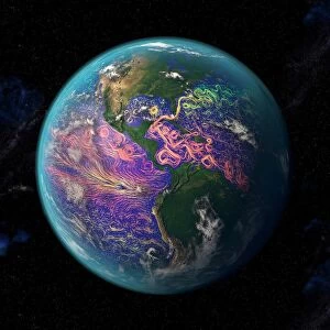
February 2000 - This image of the world was generated with data from the Shuttle Radar Topography Mission (SRTM). The SRTM Project has recently released a new global data set called SRTM30, where the original one arcsecond of latitude and longitude resolution (about 30 meters, or 98 feet, at the equator) was reduced to 30 arcseconds (about 928 meters, or 1496 feet.) This image was created from that data set and shows the world between 60 degrees south and 60 degrees north latitude, covering 80% of the Earths land mass. The image is in the Mercator Projection commonly used for maps of the world.
Two visualization methods were combined to produce the image: shading and color coding of topographic height. The shade image was derived by computing topographic slope in the northwest-southeast direction, so that northwest slopes appear bright and southeast slopes appear dark. Color coding is directly related to topographic height, with green at the lower elevations, rising through yellow and tan, to white at the highest elevations
Stocktrek Images specializes in Astronomy, Dinosaurs, Medical, Military Forces, Ocean Life, & Sci-Fi
Media ID 13056665
© Stocktrek Images
Africa America Asia Atlantic Atlantic Ocean Australia Canada Central America Continent Elevated Elevation Europe Geography Global Green Land Feature Landform Landmass Mountain Mountainous North America Pacific Pacific Ocean Projection Russia South America Topography United States World Worldwide Mercator View From Space
Photo Mug (11 oz)
Bring the wonders of our planet into your daily routine with Media Storehouse's Photo Mugs. Featuring an awe-inspiring image of the world from Stocktrek Images, this mug showcases intricate details generated by the Shuttle Radar Topography Mission (SRTM) in February 2000. The latest SRTM30 global data set adds to the stunning visual representation of our Earth. Embrace the beauty of the world with every sip from this unique and captivating mug.
A personalized photo mug blends sentimentality with functionality, making an ideal gift for cherished loved ones, close friends, or valued colleagues. Preview may show both sides of the same mug.
Elevate your coffee or tea experience with our premium white ceramic mug. Its wide, comfortable handle makes drinking easy, and you can rely on it to be both microwave and dishwasher safe. Sold in single units, preview may show both sides of the same mug so you can see how the picture wraps around.
Mug Size is 8cm high x 9.5cm diameter (3.1" x 3.7")
These are individually made so all sizes are approximate
FEATURES IN THESE COLLECTIONS
> Africa
> Related Images
> Asia
> Related Images
> Europe
> Russia
> Related Images
> North America
> Related Images
> Oceania
> Australia
> Related Images
> South America
> Related Images
EDITORS COMMENTS
This stunning print captures the world as it appeared in February 2000, using data from the Shuttle Radar Topography Mission (SRTM). The SRTM Project recently released a new global data set called SRTM30, which provided a detailed image of the Earth's land mass. In this particular image, we can see the world between 60 degrees south and 60 degrees north latitude, covering an impressive 80% of our planet's land. To create this visually striking representation, two visualization methods were combined: shading and color coding of topographic height. The shade image was generated by calculating topographic slope in the northwest-southeast direction. As a result, northwest slopes appear bright while southeast slopes appear dark. Additionally, color coding is directly linked to topographic height - green represents lower elevations and gradually transitions through yellow and tan until reaching white at the highest elevations. Displayed in Mercator Projection commonly used for world maps, this print showcases both the beauty and complexity of our planet's diverse landscapes. It serves as a reminder of Earth's vastness and highlights its natural wonders from towering mountain ranges to sprawling plains.
MADE IN THE USA
Safe Shipping with 30 Day Money Back Guarantee
FREE PERSONALISATION*
We are proud to offer a range of customisation features including Personalised Captions, Color Filters and Picture Zoom Tools
SECURE PAYMENTS
We happily accept a wide range of payment options so you can pay for the things you need in the way that is most convenient for you
* Options may vary by product and licensing agreement. Zoomed Pictures can be adjusted in the Basket.