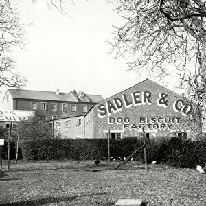
Photo Mug > Europe > United Kingdom > England > London > Sights > St James Park
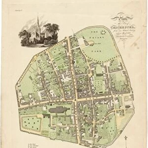
Photo Mug : Map Of Chichester, 1812


Home Decor from West Sussex County Council
Map Of Chichester, 1812
Map includes area outside of the city walls. Plan of the liberties of the City of Chichester from an actual survey taken April 1812 by George Loader, Surveyor
Printed Maps Collection
West Sussex Record Office Ref No: PM 10
West Sussex County Council Record Office contains a fascinating history of the county of West Sussex, England
Media ID 5978151
Oaklands Park Barracks South Gate Spitalfields St James St Pancras West Gate
Large Photo Mug (15 oz)
Introducing the Media Storehouse Photo Mug featuring a captivating historical map of Chichester, West Sussex. This unique mug showcases an intricately detailed map of the city and its surroundings from April 1812, as originally surveyed by George Loader. The Map of Chichester, 1812, includes the area outside the city walls, offering a fascinating glimpse into the past. Perfect for history enthusiasts or as a thoughtful gift, this sturdy mug holds your favorite beverage while showcasing the rich heritage of Chichester. Embrace the charm of history with every sip.
Elevate your coffee or tea experience with our premium white ceramic mug. Its wide, comfortable handle makes drinking easy, and you can rely on it to be both microwave and dishwasher safe. Sold in single units, preview may show both sides of the same mug so you can see how the picture wraps around.
Elevate your coffee or tea experience with our premium white ceramic mug. Its wide, comfortable handle makes drinking easy, and you can rely on it to be both microwave and dishwasher safe. Sold in single units, preview may show both sides of the same mug so you can see how the picture wraps around.
These are individually made so all sizes are approximate
FEATURES IN THESE COLLECTIONS
> Arts
> Landscape paintings
> Waterfall and river artworks
> River artworks
> Europe
> United Kingdom
> England
> London
> Sights
> St James Park
> Europe
> United Kingdom
> England
> Sussex
> Chichester
> Europe
> United Kingdom
> England
> Sussex
> Related Images
> Europe
> United Kingdom
> England
> Sussex
> River
> Europe
> United Kingdom
> England
> West Sussex
> Chichester
> Europe
> United Kingdom
> England
> West Sussex
> Related Images
> Maps and Charts
> Related Images
> West Sussex County Council
> Urban
> West Sussex County Council
> West Sussex Record Office
> Printed Maps
EDITORS COMMENTS
This print showcases a beautifully detailed Map of Chichester from the year 1812. The map, created by the skilled surveyor George Loader, goes beyond the city walls and provides an extensive plan of the liberties surrounding the City of Chichester. With its vibrant colors and intricate design, this historical map offers a fascinating glimpse into the past. It highlights significant landmarks such as St James, South Gate, St Pancras, Spitalfields, West Gate, Barracks, The Broyle, River Lavant, Oaklands Park, and The Hornet. Preserved in West Sussex Record Office's Printed Maps Collection under reference number PM 10), this remarkable piece serves as a valuable resource for historians and enthusiasts alike. Its accuracy is owed to Loader's meticulous survey taken in April 1812. As you explore this image print further with your eyes tracing every street and landmark depicted on it; you can't help but feel transported back in time to early 19th-century Chichester. This visual representation allows us to appreciate how much has changed over two centuries while also recognizing that some elements have remained constant
MADE IN THE USA
Safe Shipping with 30 Day Money Back Guarantee
FREE PERSONALISATION*
We are proud to offer a range of customisation features including Personalised Captions, Color Filters and Picture Zoom Tools
SECURE PAYMENTS
We happily accept a wide range of payment options so you can pay for the things you need in the way that is most convenient for you
* Options may vary by product and licensing agreement. Zoomed Pictures can be adjusted in the Cart.


![Royal Engineers bomb disposal team at work, [Mar 1941]](/sq/479/royal-engineers-bomb-disposal-team-work-8359434.jpg.webp)
![Chichester St. Peter the Great [Subdeanery] tithe map, 1846-1847](/sq/479/chichester-st-peter-great-subdeanery-tithe-10701869.jpg.webp)