Photo Mug > Europe > United Kingdom > England > West Sussex > Chichester
Photo Mug : Binderton Tithe Map, 1847


![]()
Home Decor From West Sussex County Council
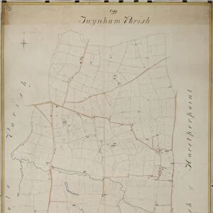
Binderton Tithe Map, 1847
By John Elliott, Surveyor, Chichester. 26.6 in. to 1 m. Original map size 83in. × 42in.
Tithe Award Map Collection
West Sussex Record Office Ref No: TD/W14
West Sussex County Council Record Office contains a fascinating history of the county of West Sussex, England
Media ID 7915660
© West Sussex County Council - All Rights Reserved
1840s Historical Mapping Parish
Large Photo Mug (15 oz)
Bring history to your morning routine with our Media Storehouse Photo Mug featuring an intriguing image from the past. This mug showcases a captivating 1847 Tithe Map of Binderton from the West Sussex County Council Archives. The intricate details of the map, originally surveyed by John Elliott, Surveyor of Chichester, transport you back in time. Each sip from this mug is a journey to the past, making your daily coffee or tea break a truly unique experience. Order yours today and start your day with a bit of history in your hands!
Elevate your coffee or tea experience with our premium white ceramic mug. Its wide, comfortable handle makes drinking easy, and you can rely on it to be both microwave and dishwasher safe. Sold in single units, preview may show both sides of the same mug so you can see how the picture wraps around.
Elevate your coffee or tea experience with our premium white ceramic mug. Its wide, comfortable handle makes drinking easy, and you can rely on it to be both microwave and dishwasher safe. Sold in single units, preview may show both sides of the same mug so you can see how the picture wraps around.
These are individually made so all sizes are approximate
FEATURES IN THESE COLLECTIONS
> Europe
> United Kingdom
> England
> Sussex
> Chichester
> Europe
> United Kingdom
> England
> Sussex
> Related Images
> Europe
> United Kingdom
> England
> West Sussex
> Chichester
> Europe
> United Kingdom
> England
> West Sussex
> Related Images
> Maps and Charts
> Early Maps
> Maps and Charts
> Related Images
> West Sussex County Council
> West Sussex Record Office
> Tithe Award Maps, 1808-1859
EDITORS COMMENTS
This print showcases the remarkable Binderton Tithe Map, meticulously crafted by the skilled hands of John Elliott, a renowned surveyor from Chichester. Dating back to 1847, this historical gem offers an intriguing glimpse into the past, shedding light on the intricate details of land ownership and usage during that era. Measuring an impressive 83 inches by 42 inches in its original form, this reduced-scale reproduction allows us to appreciate every minute detail with clarity. The map's scale is set at 26.6 inches to one meter, ensuring accuracy and precision in depicting the landscape of Binderton parish. Part of the esteemed Tithe Award Map Collection housed within West Sussex Record Office (Ref No: TD/W14), this artifact holds immense value for historians and researchers alike. It serves as a valuable resource for studying land tenure patterns and understanding how communities were structured in rural West Sussex during the mid-19th century. It is important to note that this caption focuses solely on providing information about the photograph itself rather than any commercial use associated with it. By preserving such invaluable historical mapping records like these, West Sussex County Council ensures that future generations can continue exploring our rich heritage and gain insights into our collective past.
MADE IN THE USA
Safe Shipping with 30 Day Money Back Guarantee
FREE PERSONALISATION*
We are proud to offer a range of customisation features including Personalised Captions, Color Filters and Picture Zoom Tools
SECURE PAYMENTS
We happily accept a wide range of payment options so you can pay for the things you need in the way that is most convenient for you
* Options may vary by product and licensing agreement. Zoomed Pictures can be adjusted in the Basket.


![Chichester St. Peter the Great [Subdeanery] tithe map, 1846-1847](/sq/479/chichester-st-peter-great-subdeanery-tithe-10701869.jpg.webp)