Photographic Print > Historic > Medieval architecture > Castles and fortresses > Ancient fortifications
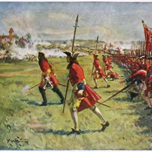
Photographic Print : Map of Fortifications of the City of Barcelona, 1706, 18th century (engraving)
")

![]()
Photo Prints from Fine Art Finder
Map of Fortifications of the City of Barcelona, 1706, 18th century (engraving)
6266320 Map of Fortifications of the City of Barcelona, 1706, 18th century (engraving); (add.info.: The true and exact Plan of all the Old and New Fortifications of the City of Barcelona, Capital of the Province of Catalonia, Spain. Dated circa 1706, in the midst of the War of Spanish Succession. After an anonymous work.); Photo © Ken Welsh. All rights reserved 2024
Media ID 38512018
© © Ken Welsh. All rights reserved 2024 / Bridgeman Images
Archival Archive Barcelona Catalan Catalonia Catalunya Catalunyan Defences War Of Spanish Succession
10"x8" Photo Print
"Step back in time with our stunning Photographic Prints from the Media Storehouse range! This exquisite piece, "Map of Fortifications of the City of Barcelona, 1706, 18th century (engraving)" by Ken Welsh from Fine Art Finder, is a masterpiece that will transport you to a bygone era. The intricate details and historical significance make this print a must-have for any art lover or history enthusiast. Bring a touch of elegance and sophistication to your home or office with this beautiful reproduction."
Photo prints are produced on Kodak professional photo paper resulting in timeless and breath-taking prints which are also ideal for framing. The colors produced are rich and vivid, with accurate blacks and pristine whites, resulting in prints that are truly timeless and magnificent. Whether you're looking to display your prints in your home, office, or gallery, our range of photographic prints are sure to impress. Dimensions refers to the size of the paper in inches.
Our Photo Prints are in a large range of sizes and are printed on Archival Quality Paper for excellent colour reproduction and longevity. They are ideal for framing (our Framed Prints use these) at a reasonable cost. Alternatives include cheaper Poster Prints and higher quality Fine Art Paper, the choice of which is largely dependant on your budget.
Estimated Product Size is 25.4cm x 20.3cm (10" x 8")
These are individually made so all sizes are approximate
Artwork printed orientated as per the preview above, with landscape (horizontal) orientation to match the source image.
FEATURES IN THESE COLLECTIONS
> Fine Art Finder
> Artists
> Edgar Hunt
> Historic
> Medieval architecture
> Castles and fortresses
> Ancient fortifications
> Maps and Charts
> Early Maps
> Maps and Charts
> Related Images
> Maps and Charts
> Spain
EDITORS COMMENTS
This print showcases a detailed Map of Fortifications of the City of Barcelona from the 18th century, specifically dating back to around 1706 during the War of Spanish Succession. The engraving provides a true and exact plan of both the old and new fortifications that surrounded the capital city of Catalonia, Spain.
The intricate illustration highlights the strategic defenses put in place to protect Barcelona, offering a glimpse into its historical significance as a stronghold in European history. The map not only serves as a valuable archival piece but also as a testament to the architectural prowess and military tactics employed during this tumultuous period.
As you study each line and detail on this engraving, you can almost feel yourself transported back in time to witness firsthand how these fortresses played a crucial role in shaping the city's destiny. From towering walls to intricate layouts, every aspect is meticulously captured in this stunning artwork by an anonymous artist.
Whether you are drawn to its historical context or simply appreciate cartography at its finest, this Map of Fortifications is sure to captivate your imagination and offer insight into Barcelona's rich past. It stands as a reminder of how artistry and strategy intersected seamlessly in creating formidable defenses for one of Europe's most iconic cities.
MADE IN THE USA
Safe Shipping with 30 Day Money Back Guarantee
FREE PERSONALISATION*
We are proud to offer a range of customisation features including Personalised Captions, Color Filters and Picture Zoom Tools
SECURE PAYMENTS
We happily accept a wide range of payment options so you can pay for the things you need in the way that is most convenient for you
* Options may vary by product and licensing agreement. Zoomed Pictures can be adjusted in the Cart.