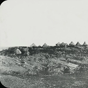
Photographic Print > Africa > Zimbabwe > Rhodesia
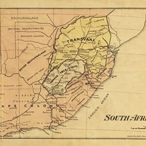
Photographic Print : Map of Matabeleland in the late 19th century, from South Africa and the Transvaal War: Vol. 1 by Louis Creswicke, published 1900 (litho)
")

![]()
Photo Prints from Fine Art Finder
Map of Matabeleland in the late 19th century, from South Africa and the Transvaal War: Vol. 1 by Louis Creswicke, published 1900 (litho)
KW371011 Map of Matabeleland in the late 19th century, from South Africa and the Transvaal War: Vol. 1 by Louis Creswicke, published 1900 (litho) by English School, (20th century); Private Collection
Media ID 32180954
© Bridgeman Images
10"x10" Photo Print
Step back in time with our exquisite selection of historical photographic prints from Media Storehouse. This captivating map, titled "Map of Matabeleland in the late 19th century, from South Africa and the Transvaal War: Vol. 1" by Louis Creswicke, published in 1900, offers a fascinating glimpse into the past. Originally published as a lithograph by English School, this rare and intriguing piece showcases the political landscape of Matabeleland during a pivotal period in African and world history. With meticulous detail and stunning clarity, this vintage print is a must-have for history enthusiasts, collectors, and anyone seeking to expand their knowledge of the past. Own a piece of history with Media Storehouse's exceptional range of photographic prints.
Photo prints are produced on Kodak professional photo paper resulting in timeless and breath-taking prints which are also ideal for framing. The colors produced are rich and vivid, with accurate blacks and pristine whites, resulting in prints that are truly timeless and magnificent. Whether you're looking to display your prints in your home, office, or gallery, our range of photographic prints are sure to impress. Dimensions refers to the size of the paper in inches.
Our Photo Prints are in a large range of sizes and are printed on Archival Quality Paper for excellent colour reproduction and longevity. They are ideal for framing (our Framed Prints use these) at a reasonable cost. Alternatives include cheaper Poster Prints and higher quality Fine Art Paper, the choice of which is largely dependant on your budget.
Estimated Product Size is 25.4cm x 25.4cm (10" x 10")
These are individually made so all sizes are approximate
Artwork printed orientated as per the preview above, with landscape (horizontal) or portrait (vertical) orientation to match the source image.
FEATURES IN THESE COLLECTIONS
> Fine Art Finder
> Artists
> English School
> Fine Art Finder
> Maps (celestial & Terrestrial)
> Africa
> South Africa
> Maps
> Africa
> South Africa
> Related Images
> Africa
> Zimbabwe
> Rhodesia
> Maps and Charts
> Related Images
EDITORS COMMENTS
This lithograph print showcases a historical treasure, the "Map of Matabeleland in the late 19th century". Created by an anonymous English School artist in the early 20th century, this map was originally published in Louis Creswicke's renowned book "South Africa and the Transvaal War: Vol. 1" in 1900. The intricate details depicted on this map offer a fascinating glimpse into the territorial landscape of Matabeleland during that era. Every contour and boundary is meticulously engraved, allowing viewers to explore and understand the region's geography with precision. Matabeleland, located within Rhodesia (now Zimbabwe), holds significant historical importance due to its involvement in various conflicts and colonization efforts. This map serves as a valuable resource for historians, cartographers, and enthusiasts alike who seek to study or trace the evolution of this region over time. Preserved within a private collection, this lithograph print not only captures an important piece of history but also highlights the skillful craftsmanship involved in creating such detailed maps. Its artistic value lies not only in its accuracy but also in its ability to transport us back to a pivotal period when exploration and mapping played crucial roles in shaping our understanding of different territories around the world. With Ken Welsh's copyright stamp ensuring authenticity, this remarkable artwork stands as both an educational tool and a testament to human curiosity about our surroundings throughout history.
MADE IN THE USA
Safe Shipping with 30 Day Money Back Guarantee
FREE PERSONALISATION*
We are proud to offer a range of customisation features including Personalised Captions, Color Filters and Picture Zoom Tools
SECURE PAYMENTS
We happily accept a wide range of payment options so you can pay for the things you need in the way that is most convenient for you
* Options may vary by product and licensing agreement. Zoomed Pictures can be adjusted in the Cart.