Photographic Print > Arts > Artists > S > Christopher Saxton
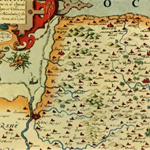
Photographic Print : A Map of Westmorland and Cumberland, 1576 (hand-coloured engraving)
")


![]()
Photo Prints from Fine Art Finder
A Map of Westmorland and Cumberland, 1576 (hand-coloured engraving)
985982 A Map of Westmorland and Cumberland, 1576 (hand-coloured engraving) by Saxton, Christopher (c.1542-c.1610); 38x48.5 cm; Private Collection; (add.info.: A Map of Westmorland and Cumberland; Westmorlandiae et Cumberlandiae Comit: Nova Vera et Elaborata Descriptio. Christopher Saxton (circa 1540-1610). Hand-coloured engraving. Engraved in 1576. 38 x 48.5cm.); Photo eChristies Images; English, out of copyright
Media ID 22202880
© Christie's Images / Bridgeman Images
1576 Armorial Cartographer Coats Of Arms Crest Cumberland Cumbria English Text Geographic Hand Colored Hand Coloring Hand Coloured Hand Colouring Hand Tinted Handcolored Language Lettering Navigational Equipment Prints Profession Westmorland Word Christopher Saxton Natural Space
10"x8" Photo Print
Discover the historical charm of yesteryears with our exquisite range of Photographic Prints from Media Storehouse. This particular print showcases an intriguing and beautifully preserved map - "A Map of Westmorland and Cumberland, 1576 (hand-coloured engraving)" by Christopher Saxton. Meticulously crafted from a rare hand-coloured engraving, this vintage map takes you on a journey back in time, revealing the intricate details of the Westmorland and Cumberland regions as they appeared over 400 years ago. Add a touch of history and character to your space with this captivating and unique piece from Bridgeman Images, Fine Art Finder.
Photo prints are produced on Kodak professional photo paper resulting in timeless and breath-taking prints which are also ideal for framing. The colors produced are rich and vivid, with accurate blacks and pristine whites, resulting in prints that are truly timeless and magnificent. Whether you're looking to display your prints in your home, office, or gallery, our range of photographic prints are sure to impress. Dimensions refers to the size of the paper in inches.
Our Photo Prints are in a large range of sizes and are printed on Archival Quality Paper for excellent colour reproduction and longevity. They are ideal for framing (our Framed Prints use these) at a reasonable cost. Alternatives include cheaper Poster Prints and higher quality Fine Art Paper, the choice of which is largely dependant on your budget.
Estimated Product Size is 25.4cm x 20.3cm (10" x 8")
These are individually made so all sizes are approximate
Artwork printed orientated as per the preview above, with landscape (horizontal) orientation to match the source image.
FEATURES IN THESE COLLECTIONS
> Fine Art Finder
> Artists
> Christopher Saxton
> Fine Art Finder
> Artists
> Giovanni Battista Piranesi
> Fine Art Finder
> Temp Classification
> Arts
> Artists
> S
> Christopher Saxton
> Europe
> United Kingdom
> England
> Cumberland
> Europe
> United Kingdom
> England
> Cumbria
> Related Images
> Europe
> United Kingdom
> England
> Maps
> Europe
> United Kingdom
> England
> Westmorland
> Europe
> United Kingdom
> Maps
EDITORS COMMENTS
This hand-coloured engraving, titled "A Map of Westmorland and Cumberland, 1576" takes us back in time to the rich history of cartography. Created by Christopher Saxton around 1576, this meticulously detailed map showcases the counties of Westmorland and Cumberland in England. Measuring at 38x48.5 cm, this print is a true testament to Saxton's skill as a cartographer. The intricate lines and delicate shading bring the landscape to life, while the vibrant colours add an element of enchantment. The map not only provides geographical information but also offers glimpses into the cultural heritage of these regions. Coats of arms are proudly displayed throughout, representing noble families and their ancestral ties to these lands. The English text accompanying the map further enhances our understanding of its significance. As we explore this piece closely, we can almost imagine ourselves navigating through its coastal contours with navigational equipment from that era. It serves as a reminder that maps were once essential tools for exploration and trade. With its meticulous detail and historical context, this hand-coloured engraving transports us back in time to an era when cartographers like Christopher Saxton played a vital role in shaping our understanding of geography. It is truly a treasure worth cherishing for both its artistic beauty and historical value.
MADE IN THE USA
Safe Shipping with 30 Day Money Back Guarantee
FREE PERSONALISATION*
We are proud to offer a range of customisation features including Personalised Captions, Color Filters and Picture Zoom Tools
SECURE PAYMENTS
We happily accept a wide range of payment options so you can pay for the things you need in the way that is most convenient for you
* Options may vary by product and licensing agreement. Zoomed Pictures can be adjusted in the Cart.