Photographic Print > Arts > Artists > A > John Atkinson
Photographic Print : Chart of Jamaica, Barbados, St Christopher, Martinique, Antigua and Bermuda, 1713 (coloured engraving)
")

![]()
Photo Prints from Fine Art Finder
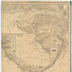
Chart of Jamaica, Barbados, St Christopher, Martinique, Antigua and Bermuda, 1713 (coloured engraving)
7340629 Chart of Jamaica, Barbados, St Christopher, Martinique, Antigua and Bermuda, 1713 (coloured engraving) by Seller, John (1632-97); National Maritime Museum, London, UK; (add.info.: Creator: John Seller
From Seller's English Pilot Fourth Book, West India Navigation, published 1713. John Seller was Hydrographer to King Charles II. In 1677 he went into partnership with Thornton, Fisher, Atkinson and Colson.); © National Maritime Museum, Greenwich, London
Media ID 38412588
© © National Maritime Museum, Greenwich, London / Bridgeman Images
Barbados Bermuda British West Indies Central America Jamaica Jamaica Jamaican Jamaican Jamaicans Martinique The Bermudas West Indies
10"x8" Photo Print
Discover the rich history and intricate details of the Caribbean with this stunning coloured engraving from 1713. Perfect for adding a touch of elegance to any space, this print captures the beauty of Jamaica, Barbados, St Christopher, Martinique, Antigua and Bermuda in exquisite detail.
Photo prints are produced on Kodak professional photo paper resulting in timeless and breath-taking prints which are also ideal for framing. The colors produced are rich and vivid, with accurate blacks and pristine whites, resulting in prints that are truly timeless and magnificent. Whether you're looking to display your prints in your home, office, or gallery, our range of photographic prints are sure to impress. Dimensions refers to the size of the paper in inches.
Our Photo Prints are in a large range of sizes and are printed on Archival Quality Paper for excellent colour reproduction and longevity. They are ideal for framing (our Framed Prints use these) at a reasonable cost. Alternatives include cheaper Poster Prints and higher quality Fine Art Paper, the choice of which is largely dependant on your budget.
Estimated Product Size is 25.4cm x 20.3cm (10" x 8")
These are individually made so all sizes are approximate
Artwork printed orientated as per the preview above, with landscape (horizontal) orientation to match the source image.
FEATURES IN THESE COLLECTIONS
> Fine Art Finder
> Artists
> James & Son Imray
> Fine Art Finder
> Artists
> John Seller
> Arts
> Artists
> A
> John Atkinson
> Arts
> Artists
> C
> King Charles
> Arts
> Artists
> S
> John Seller
> Arts
> Artists
> W
> Charles White
> Arts
> Artists
> W
> John White
> Asia
> India
> Related Images
> Europe
> United Kingdom
> England
> Herefordshire
> Ledbury
> Charles II
> Europe
> United Kingdom
> England
> London
> Boroughs
> Greenwich
> Europe
> United Kingdom
> England
> London
> Museums
> British Museum
EDITORS COMMENTS
This stunning coloured engraving from 1713, created by John Seller, showcases a detailed chart of Jamaica, Barbados, St Christopher, Martinique, Antigua and Bermuda. The intricate map is part of Seller's 'English Pilot' Fourth Book, West India Navigation and was published during the early 18th century.
John Seller, who served as Hydrographer to King Charles II, collaborated with Thornton, Fisher, Atkinson and Colson in 1677 to produce this masterpiece of cartography. The map provides a glimpse into the colonial era of the British West Indies and highlights the strategic importance of these islands in the Caribbean.
The black-and-white print captures the essence of exploration and navigation during that period. It offers a historical perspective on the geographical layout of these territories in North America and Central America.
As we admire this piece from the National Maritime Museum in London, we are transported back to a time when maps were essential tools for sailors navigating uncharted waters. The attention to detail in depicting coastlines, rivers and settlements reflects Seller's dedication to accuracy in his work.
This engraving serves as a reminder of our rich maritime history and invites us to appreciate the artistry involved in creating such intricate maps centuries ago.
MADE IN THE USA
Safe Shipping with 30 Day Money Back Guarantee
FREE PERSONALISATION*
We are proud to offer a range of customisation features including Personalised Captions, Color Filters and Picture Zoom Tools
SECURE PAYMENTS
We happily accept a wide range of payment options so you can pay for the things you need in the way that is most convenient for you
* Options may vary by product and licensing agreement. Zoomed Pictures can be adjusted in the Cart.