Photographic Print > Arts > Artists > P > Antonio Pigafetta
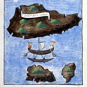
Photographic Print : The map of Antonio Pigafetta (16th century Italian sailor) of Magellan Detroit to navigate around the land, 1519-1520. The north is represented downstairs. Engraving
 of Magellan Detroit to navigate around the land, 1519-1520. The north is represented downstairs. Engraving")
![]()
Photo Prints From Fine Art Finder
The map of Antonio Pigafetta (16th century Italian sailor) of Magellan Detroit to navigate around the land, 1519-1520. The north is represented downstairs. Engraving
NWI4902432 The map of Antonio Pigafetta (16th century Italian sailor) of Magellan Detroit to navigate around the land, 1519-1520. The north is represented downstairs. Engraving. Pigafetta's map of the Strait of Magellan, to circumnavigate the earth, 1519-1520 (north is at the bottom).; (add.info.: The map of Antonio Pigafetta (16th century Italian sailor) of Magellan Detroit to navigate around the land, 1519-1520. The north is represented downstairs. Engraving. Pigafetta's map of the Strait of Magellan, to circumnavigate the earth, 1519-1520 (north is at the bottom).); Photo © North Wind Pictures
Media ID 38423930
© © North Wind Pictures / Bridgeman Images
Discovered From America World Tour Geographical Map
12"x8" Photo Print
Explore the fascinating world of historical navigation with this stunning photographic print of Antonio Pigafetta's map from the 16th century. Perfect for history buffs and art enthusiasts alike, this piece captures the intricate details of Magellan's Detroit as seen through the eyes of an Italian sailor. Add a touch of vintage charm to your space with this unique engraving from Fine Art Finder, available at Media Storehouse.
Photo prints are produced on Kodak professional photo paper resulting in timeless and breath-taking prints which are also ideal for framing. The colors produced are rich and vivid, with accurate blacks and pristine whites, resulting in prints that are truly timeless and magnificent. Whether you're looking to display your prints in your home, office, or gallery, our range of photographic prints are sure to impress. Dimensions refers to the size of the paper in inches.
Our Photo Prints are in a large range of sizes and are printed on Archival Quality Paper for excellent colour reproduction and longevity. They are ideal for framing (our Framed Prints use these) at a reasonable cost. Alternatives include cheaper Poster Prints and higher quality Fine Art Paper, the choice of which is largely dependant on your budget.
Estimated Image Size (if not cropped) is 18.7cm x 30.4cm (7.4" x 12")
Estimated Product Size is 20.3cm x 30.5cm (8" x 12")
These are individually made so all sizes are approximate
Artwork printed orientated as per the preview above, with portrait (vertical) orientation to match the source image.
FEATURES IN THESE COLLECTIONS
> Fine Art Finder
> Artists
> Pasquier (workshop of) Grenier
> Arts
> Artists
> P
> Antonio Pigafetta
> Europe
> France
> Canton
> Landes
> Maps and Charts
> Italy
> Maps and Charts
> Related Images
> Maps and Charts
> World
> North America
> United States of America
> Maps
EDITORS COMMENTS
This stunning print captures the intricate map created by Antonio Pigafetta, a 16th-century Italian sailor who accompanied Magellan on his historic voyage to circumnavigate the earth. The map depicts the Detroit of Magellan, showcasing Pigafetta's detailed navigation skills and knowledge of the land. What makes this map truly unique is that north is represented at the bottom, providing a different perspective for viewers accustomed to traditional maps.
Pigafetta's map serves as a testament to the bravery and curiosity of early explorers who ventured into uncharted territories in search of new lands and discoveries. It offers a glimpse into the challenges faced by sailors during this time period, relying on their skills and instruments to navigate treacherous waters.
As we admire this engraving, we are reminded of the importance of exploration and discovery in shaping our understanding of the world. Pigafetta's contributions to cartography continue to inspire us today, highlighting the power of human ingenuity and determination in overcoming obstacles.
This print is not just a historical artifact but also a work of art that invites us to reflect on our place in an ever-changing world filled with endless possibilities waiting to be explored.
MADE IN THE USA
Safe Shipping with 30 Day Money Back Guarantee
FREE PERSONALISATION*
We are proud to offer a range of customisation features including Personalised Captions, Color Filters and Picture Zoom Tools
SECURE PAYMENTS
We happily accept a wide range of payment options so you can pay for the things you need in the way that is most convenient for you
* Options may vary by product and licensing agreement. Zoomed Pictures can be adjusted in the Basket.