Photographic Print > North America > United States of America > New Jersey > Trenton
Photographic Print : War of Independence or American Revolution (1775-1783): Map of the vicinity of Philadelphia (Pennsylvania), Valley Forge and Brandywine, the sites of the War of Independence around the Delaware River, Fort Mifflin and Trenton (New Jersey)
: Map of the vicinity of Philadelphia (Pennsylvania), Valley Forge and Brandywine, the sites of the War of Independence around the Delaware River, Fort Mifflin and Trenton (New Jersey)")

![]()
Photo Prints from Fine Art Finder
War of Independence or American Revolution (1775-1783): Map of the vicinity of Philadelphia (Pennsylvania), Valley Forge and Brandywine, the sites of the War of Independence around the Delaware River, Fort Mifflin and Trenton (New Jersey)
NWI4841014 War of Independence or American Revolution (1775-1783): Map of the vicinity of Philadelphia (Pennsylvania), Valley Forge and Brandywine, the sites of the War of Independence around the Delaware River, Fort Mifflin and Trenton (New Jersey). Coloured water, 19th century.; (add.info.: War of Independence or American Revolution (1775-1783): Map of the vicinity of Philadelphia (Pennsylvania), Valley Forge and Brandywine, the sites of the War of Independence around the Delaware River, Fort Mifflin and Trenton (New Jersey). Coloured water, 19th century.); Photo © North Wind Pictures
Media ID 38483846
© © North Wind Pictures / Bridgeman Images
Us Independence War War Of Independence Geographical Map
10"x8" Photo Print
Explore the historic sites of the American Revolution with this detailed map of Philadelphia, Valley Forge, and Brandywine. Perfect for history buffs and enthusiasts alike, this print captures the essence of one of America's most pivotal moments in time. Add a touch of patriotism to your space with this stunning piece from Fine Art Finder.
Photo prints are produced on Kodak professional photo paper resulting in timeless and breath-taking prints which are also ideal for framing. The colors produced are rich and vivid, with accurate blacks and pristine whites, resulting in prints that are truly timeless and magnificent. Whether you're looking to display your prints in your home, office, or gallery, our range of photographic prints are sure to impress. Dimensions refers to the size of the paper in inches.
Our Photo Prints are in a large range of sizes and are printed on Archival Quality Paper for excellent colour reproduction and longevity. They are ideal for framing (our Framed Prints use these) at a reasonable cost. Alternatives include cheaper Poster Prints and higher quality Fine Art Paper, the choice of which is largely dependant on your budget.
Estimated Product Size is 25.4cm x 20.3cm (10" x 8")
These are individually made so all sizes are approximate
Artwork printed orientated as per the preview above, with landscape (horizontal) or portrait (vertical) orientation to match the source image.
FEATURES IN THESE COLLECTIONS
> Fine Art Finder
> Artists
> Pasquier (workshop of) Grenier
> Arts
> Landscape paintings
> Waterfall and river artworks
> River artworks
> Maps and Charts
> Early Maps
> Maps and Charts
> Related Images
> North America
> Related Images
> North America
> United States of America
> Delaware
> Related Images
> North America
> United States of America
> Maps
> North America
> United States of America
> New Jersey
> Related Images
> North America
> United States of America
> New Jersey
> Trenton
> North America
> United States of America
> Pennsylvania
> Philadelphia
EDITORS COMMENTS
This stunning 19th-century map captures the strategic locations of Philadelphia, Valley Forge, Brandywine, Fort Mifflin, and Trenton during the War of Independence or American Revolution (1775-1783). The intricate details and vibrant colors bring to life the historic sites that played a crucial role in shaping the outcome of this pivotal moment in American history.
As you study the map, you can almost envision the troops marching through these areas, fighting for freedom and independence from British rule. Each line and symbol on the map tells a story of bravery, sacrifice, and determination as patriots fought against tyranny to establish a new nation.
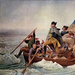
The Delaware River serves as a central point on this map, connecting key locations where battles were fought and victories were won. From Valley Forge's harsh winter encampment to Trenton's daring surprise attack by General Washington, every inch of this map is filled with historical significance.
Whether you're a history buff or simply appreciate fine cartography, this print is sure to captivate your imagination and transport you back to a time when America was born out of revolution. Display it proudly in your home or office as a reminder of the sacrifices made by those who came before us to secure our freedoms.
MADE IN THE USA
Safe Shipping with 30 Day Money Back Guarantee
FREE PERSONALISATION*
We are proud to offer a range of customisation features including Personalised Captions, Color Filters and Picture Zoom Tools
SECURE PAYMENTS
We happily accept a wide range of payment options so you can pay for the things you need in the way that is most convenient for you
* Options may vary by product and licensing agreement. Zoomed Pictures can be adjusted in the Cart.