Photographic Print > Maps and Charts > Early Maps
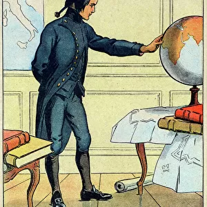
Photographic Print : The Murer plan is a map of Zurich, 1576 (engraving)
")
![]()
Photo Prints from Fine Art Finder
The Murer plan is a map of Zurich, 1576 (engraving)
2911883 The Murer plan is a map of Zurich, 1576 (engraving); (add.info.: The Murer plan is a map of Zurich, printed in 1576 by Jos Murer (1530-1580).); Universal History Archive/UIG
Media ID 38249506
© Universal History Archive/UIG / Bridgeman Images
12"x8" Photo Print
Explore the intricate details of Zurich's cityscape with our range of Photographic Prints featuring "The Murer plan is a map of Zurich, 1576" by Bridgeman Images. This historic engraving captures the essence of Switzerland's vibrant capital in stunning detail.
Photo prints are produced on Kodak professional photo paper resulting in timeless and breath-taking prints which are also ideal for framing. The colors produced are rich and vivid, with accurate blacks and pristine whites, resulting in prints that are truly timeless and magnificent. Whether you're looking to display your prints in your home, office, or gallery, our range of photographic prints are sure to impress. Dimensions refers to the size of the paper in inches.
Our Photo Prints are in a large range of sizes and are printed on Archival Quality Paper for excellent colour reproduction and longevity. They are ideal for framing (our Framed Prints use these) at a reasonable cost. Alternatives include cheaper Poster Prints and higher quality Fine Art Paper, the choice of which is largely dependant on your budget.
Estimated Product Size is 30.5cm x 20.3cm (12" x 8")
These are individually made so all sizes are approximate
Artwork printed orientated as per the preview above, with landscape (horizontal) orientation to match the source image.
FEATURES IN THESE COLLECTIONS
> Fine Art Finder
> Artists
> Raymond de la Neziere
> Maps and Charts
> Early Maps
> Maps and Charts
> Related Images
EDITORS COMMENTS
This print showcases the intricate and detailed Murer plan, a historic map of Zurich from 1576. Created by Jos Murer, a skilled cartographer of the 16th century, this engraving offers a fascinating glimpse into the layout and architecture of Zurich during that time.
The Murer plan is not just a simple map; it is a work of art that reflects the craftsmanship and precision of its creator. Every street, building, and landmark is meticulously depicted with stunning accuracy, providing viewers with a window into the past.
As you study this print closely, you can almost imagine yourself walking through the streets of Zurich in 1576. The bustling city comes to life before your eyes as you trace your finger along its winding roads and alleys.
This piece serves as both a historical document and a visual masterpiece. It reminds us of the rich heritage and cultural significance of maps in preserving our collective memory.
Whether you are an avid history buff or simply appreciate fine art, this print is sure to captivate your imagination and transport you back in time to experience Zurich as it once was centuries ago.
MADE IN THE USA
Safe Shipping with 30 Day Money Back Guarantee
FREE PERSONALISATION*
We are proud to offer a range of customisation features including Personalised Captions, Color Filters and Picture Zoom Tools
SECURE PAYMENTS
We happily accept a wide range of payment options so you can pay for the things you need in the way that is most convenient for you
* Options may vary by product and licensing agreement. Zoomed Pictures can be adjusted in the Cart.