Photographic Print > Fine Art Finder > Schools > English School
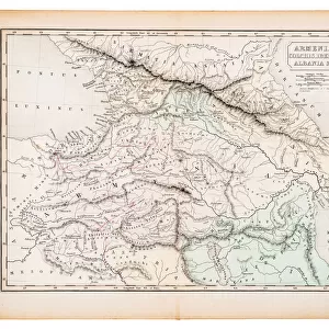
Photographic Print : Map of Armenia, Colchis, Iberia and Albania, from The Atlas of Ancient Geography


Please select a smaller print size for this image
![]()
Photo Prints from Fine Art Finder
Map of Armenia, Colchis, Iberia and Albania, from The Atlas of Ancient Geography
KW288096 Map of Armenia, Colchis, Iberia and Albania, from The Atlas of Ancient Geography, by Samuel Butler, published in London, c.1829 (colour litho) by English School, (19th century); Private Collection; Ken Welsh; English, out of copyright
Media ID 12791709
© www.bridgemanimages.com
10"x8" Photo Print
Discover the rich history and culture of ancient Armenia, Colchis, Iberia, and Albania with this beautifully detailed and vibrant Map Print from Media Storehouse. Originating from The Atlas of Ancient Geography by Samuel Butler, published in London around 1829, this captivating map is a coloured lithograph by the English School. This eye-catching piece is not just a map, but a window into the past, transporting you back to a time of ancient civilizations and exploration. Bring history to life in your home or office with this exquisite and intriguing addition to your decor.
Photo prints are produced on Kodak professional photo paper resulting in timeless and breath-taking prints which are also ideal for framing. The colors produced are rich and vivid, with accurate blacks and pristine whites, resulting in prints that are truly timeless and magnificent. Whether you're looking to display your prints in your home, office, or gallery, our range of photographic prints are sure to impress. Dimensions refers to the size of the paper in inches.
Our Photo Prints are in a large range of sizes and are printed on Archival Quality Paper for excellent colour reproduction and longevity. They are ideal for framing (our Framed Prints use these) at a reasonable cost. Alternatives include cheaper Poster Prints and higher quality Fine Art Paper, the choice of which is largely dependant on your budget.
Estimated Product Size is 25.4cm x 20.3cm (10" x 8")
These are individually made so all sizes are approximate
Artwork printed orientated as per the preview above, with landscape (horizontal) or portrait (vertical) orientation to match the source image.
EDITORS COMMENTS
This print showcases a remarkable piece of history - the "Map of Armenia, Colchis, Iberia and Albania" from The Atlas of Ancient Geography. Created by Samuel Butler and published in London around 1829, this exquisite map offers a glimpse into the past with its intricate details and vibrant colors. The map takes us on a journey through time as we explore the ancient lands of Armenia, Colchis, Iberia, and Albania. Each region is meticulously depicted with precision and accuracy, allowing us to visualize the geographical features that shaped these civilizations. From towering mountains to winding rivers, this map highlights the diverse landscapes that once thrived in these territories. It invites us to imagine how people navigated through these lands centuries ago and how they interacted with their surroundings. As we study this masterpiece closely, it becomes evident that cartography is not just about geography; it's an art form that tells stories of cultures long gone. This particular print captures our attention with its rich hues and fine lithographic technique. Whether you are a history enthusiast or simply appreciate beautiful artwork, this print will transport you back in time. It serves as a reminder of the importance of preserving our collective heritage while also celebrating the artistic achievements found within historical maps like this one.
MADE IN THE USA
Safe Shipping with 30 Day Money Back Guarantee
FREE PERSONALISATION*
We are proud to offer a range of customisation features including Personalised Captions, Color Filters and Picture Zoom Tools
SECURE PAYMENTS
We happily accept a wide range of payment options so you can pay for the things you need in the way that is most convenient for you
* Options may vary by product and licensing agreement. Zoomed Pictures can be adjusted in the Cart.