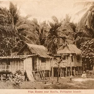
Photographic Print > Asia > Philippines > Maps
Photographic Print : Map of Manila, c.1900 (engraving)
")

![]()
Photo Prints from Fine Art Finder
Map of Manila, c.1900 (engraving)
533340 Map of Manila, c.1900 (engraving); (add.info.: Map of Manila Bay, Philippines, circa 1902, from the 10th edition of Encyclopaedia Britannica.); Encyclopaedia Britannica/UIG
Media ID 38139010
© Encyclopaedia Britannica/UIG / Bridgeman Images
1902 19th Century Style Capital Cities Filipino Guidance Illustration Technique Manila Navigational Equipment Old Fashioned Philippines Physical Geography South China Sea South East Asia The Past Western Script Luzon Island Manila Bay
10"x8" Photo Print
Explore the rich history of Manila with this stunning engraving from 1900. Perfect for adding a touch of vintage charm to any space, this print captures the intricate details of Manila Bay in the Philippines. A unique piece for any art lover or history buff.
Photo prints are produced on Kodak professional photo paper resulting in timeless and breath-taking prints which are also ideal for framing. The colors produced are rich and vivid, with accurate blacks and pristine whites, resulting in prints that are truly timeless and magnificent. Whether you're looking to display your prints in your home, office, or gallery, our range of photographic prints are sure to impress. Dimensions refers to the size of the paper in inches.
Our Photo Prints are in a large range of sizes and are printed on Archival Quality Paper for excellent colour reproduction and longevity. They are ideal for framing (our Framed Prints use these) at a reasonable cost. Alternatives include cheaper Poster Prints and higher quality Fine Art Paper, the choice of which is largely dependant on your budget.
Estimated Product Size is 20.3cm x 25.4cm (8" x 10")
These are individually made so all sizes are approximate
Artwork printed orientated as per the preview above, with portrait (vertical) orientation to match the source image.
FEATURES IN THESE COLLECTIONS
> Fine Art Finder
> Temp Classification
> Asia
> China
> Lakes
> Related Images
> Asia
> Philippines
> Lakes
> Related Images
> Asia
> Philippines
> Manila
> Asia
> Philippines
> Maps
> Asia
> Philippines
> Related Images
> Maps and Charts
> Related Images
EDITORS COMMENTS
This stunning engraving of a Map of Manila, circa 1900, offers a glimpse into the past with its intricate details and historical significance. The map showcases the capital city of the Philippines, Manila Bay, and Luzon Island in exquisite 19th-century style.
As we study this piece of cartography, we are transported back in time to an era of exploration and discovery. The Western script used on the map adds to its old-fashioned charm, while the coastline and navigational equipment depicted provide insight into how sailors once charted their course through these waters.
The Map of Manila is not just a geographical representation but also a window into the physical geography of South East Asia. It serves as a reminder of the rich history and cultural heritage that defines this region.
With no people present in the image, we are left to marvel at the intricacy and attention to detail put into creating this illustration. From Manila Bay to Lake Manilla, every feature is meticulously rendered for both practical guidance and aesthetic pleasure.
This print from Fine Art Finder is more than just a map – it is a work of art that captures the essence of Manila in all its glory.
MADE IN THE USA
Safe Shipping with 30 Day Money Back Guarantee
FREE PERSONALISATION*
We are proud to offer a range of customisation features including Personalised Captions, Color Filters and Picture Zoom Tools
SECURE PAYMENTS
We happily accept a wide range of payment options so you can pay for the things you need in the way that is most convenient for you
* Options may vary by product and licensing agreement. Zoomed Pictures can be adjusted in the Cart.