Photographic Print > Europe > Portugal > Maps
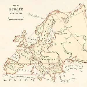
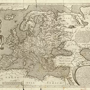
Photographic Print : Map of Europe 1721


![]()
Photo Prints from Fine Art Storehouse
Map of Europe 1721
Unleash your creativity and transform your space into a visual masterpiece!
Nastasic
Media ID 13593165
© Nikola Nastasic
62990 Earth Globe Man Made Object Globe Navigational Equipment Portugal World Map Obsolete Retro Styled
10"x8" Photo Print
Photo prints are produced on Kodak professional photo paper resulting in timeless and breath-taking prints which are also ideal for framing. The colors produced are rich and vivid, with accurate blacks and pristine whites, resulting in prints that are truly timeless and magnificent. Whether you're looking to display your prints in your home, office, or gallery, our range of photographic prints are sure to impress. Dimensions refers to the size of the paper in inches.
Our Photo Prints are in a large range of sizes and are printed on Archival Quality Paper for excellent colour reproduction and longevity. They are ideal for framing (our Framed Prints use these) at a reasonable cost. Alternatives include cheaper Poster Prints and higher quality Fine Art Paper, the choice of which is largely dependant on your budget.
Estimated Product Size is 25.4cm x 20.3cm (10" x 8")
These are individually made so all sizes are approximate
Artwork printed orientated as per the preview above, with landscape (horizontal) or portrait (vertical) orientation to match the source image.
FEATURES IN THESE COLLECTIONS
> Fine Art Storehouse
> The Magical World of Illustration
> Nastasic Images & Illustrations
> Fine Art Storehouse
> Map
> Historical Maps
> Fine Art Storehouse
> Map
> Italian Maps
> Europe
> Germany
> Related Images
> Europe
> Portugal
> Related Images
EDITORS COMMENTS
This print showcases a remarkable piece of cartographic history, the "Map of Europe 1721". With its retro-styled and antique appearance, this engraved image takes us back to a time when physical geography was meticulously depicted by skilled artisans. The intricate details and craftsmanship evident in this engraving make it a true work of art. As we gaze upon this obsolete map, we are transported to an era where borders were different, nations had yet to emerge or transform, and political landscapes were vastly distinct from what we know today. From Spain and Portugal in the west to Italy and Germany in the heartland of Europe, every country is carefully outlined with precision. The charm of this old-world map lies not only in its historical significance but also in its ability to evoke curiosity about our past. It reminds us that centuries ago, explorers relied on such navigational equipment as globes to navigate uncharted territories across the Earth. Nastasic's illustration captures the essence of this timeless artifact flawlessly. Its horizontal composition allows for easy appreciation of each element within the frame. Whether you are an avid collector or simply fascinated by ancient maps, this stunning print will undoubtedly add character and sophistication to any space it adorns.
MADE IN THE USA
Safe Shipping with 30 Day Money Back Guarantee
FREE PERSONALISATION*
We are proud to offer a range of customisation features including Personalised Captions, Color Filters and Picture Zoom Tools
SECURE PAYMENTS
We happily accept a wide range of payment options so you can pay for the things you need in the way that is most convenient for you
* Options may vary by product and licensing agreement. Zoomed Pictures can be adjusted in the Cart.