Photographic Print > North America > Belize > Maps
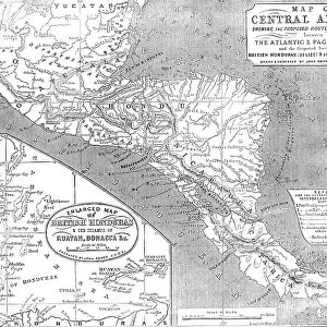
Photographic Print : Antique map - Central America


![]()
Photo Prints from Fine Art Storehouse
Antique map - Central America
Antique map of Central America, 1864
Unleash your creativity and transform your space into a visual masterpiece!
duncan1890
Media ID 15256745
© duncan1890
1860 1869 Aging Process Belize Central America Condition Equipment Guatemala Honduras Image Created 1860 1869 Mexico Navigational Equipment Nicaragua North America Panama Past Retro Revival Styles The Americas El Salvador Image Created 19th Century Obsolete Victorian Style
10"x8" Photo Print
Step back in time with our exquisite Antique Map of Central America print from the Media Storehouse Fine Art Storehouse collection. Created in 1864 by skilled cartographer duncan1890, this captivating piece showcases the historical geography of Central America in intricate detail. Each line and marking on the map tells a story of exploration and discovery. Bring a touch of history and vintage charm to your space with this stunning antique map print. Order now and travel back in time with every glance.
Photo prints are produced on Kodak professional photo paper resulting in timeless and breath-taking prints which are also ideal for framing. The colors produced are rich and vivid, with accurate blacks and pristine whites, resulting in prints that are truly timeless and magnificent. Whether you're looking to display your prints in your home, office, or gallery, our range of photographic prints are sure to impress. Dimensions refers to the size of the paper in inches.
Our Photo Prints are in a large range of sizes and are printed on Archival Quality Paper for excellent colour reproduction and longevity. They are ideal for framing (our Framed Prints use these) at a reasonable cost. Alternatives include cheaper Poster Prints and higher quality Fine Art Paper, the choice of which is largely dependant on your budget.
Estimated Product Size is 25.4cm x 20.3cm (10" x 8")
These are individually made so all sizes are approximate
Artwork printed orientated as per the preview above, with landscape (horizontal) orientation to match the source image.
FEATURES IN THESE COLLECTIONS
> Fine Art Storehouse
> Map
> Historical Maps
> Maps and Charts
> Related Images
> North America
> Belize
> Maps
> North America
> Belize
> Related Images
> North America
> El Salvador
> Maps
> North America
> El Salvador
> Related Images
> North America
> Guatemala
> Maps
> North America
> Guatemala
> Related Images
> North America
> Honduras
> Maps
> North America
> Honduras
> Related Images
EDITORS COMMENTS
This print showcases an exquisite antique map of Central America, dating back to 1864. With its retro revival and unmistakable 19th-century style, this piece takes us on a journey through time. The intricate details and craftsmanship of the cartography transport us to an era when maps were not just navigational tools but works of art. The image captures the essence of a bygone era, evoking feelings of nostalgia and curiosity about the history it represents. Its color palette reflects the aging process that has naturally occurred over more than a century, adding to its allure. This Victorian-style illustration and painting offer a glimpse into the past, reminding us of how far we have come in terms of technology and geographical knowledge. From El Salvador to Belize, Panama to Nicaragua, Honduras to Guatemala – every country in Central America is meticulously depicted on this map. It also includes Mexico as part of North America, emphasizing the interconnectedness between these regions known collectively as "the Americas". As we admire this antique treasure, we are reminded not only of our rich history but also how much things have changed since its creation. This piece serves as a testament to human ingenuity in creating navigational equipment during that time period. Duncan1890's skillful preservation allows us today to appreciate this beautiful relic from another age – a window into Central America's past for all lovers of art and history alike.
MADE IN THE USA
Safe Shipping with 30 Day Money Back Guarantee
FREE PERSONALISATION*
We are proud to offer a range of customisation features including Personalised Captions, Color Filters and Picture Zoom Tools
SECURE PAYMENTS
We happily accept a wide range of payment options so you can pay for the things you need in the way that is most convenient for you
* Options may vary by product and licensing agreement. Zoomed Pictures can be adjusted in the Cart.