Photographic Print > Europe > United Kingdom > Scotland > Fife > Falkland
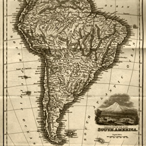
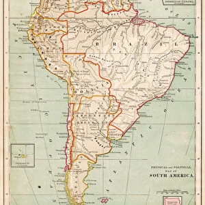
Photographic Print : Antquie Map of South America


![]()
Photo Prints from Fine Art Storehouse
Antquie Map of South America
Vintage map of South America from 1837
Unleash your creativity and transform your space into a visual masterpiece!
duncan1890
Media ID 13666631
© duncan1890
Amazon Region Argentina Atlantic Islands Bolivia Brazil Chart Chile Colombia Document Ecuador Ephemera Equator Equator Line Equipment Falkland Islands French Overseas Territory Geographical Locations Guyana Historical Document Image Date Information Equipment Manufactured Object Navigational Equipment Objects Equipment Paraguay Past Peru Printed Media South America South Georgia Island Styles The Americas Topography Travel Locations Uruguay Venezuela Amazonia French Guiana Image Created 19th Century Obsolete South Georgia Suriname Tierra Del Fuego Tierra Del Fuego Archipelago Tierra Del Fuego Province Argentina Victorian Style
10"x8" Photo Print
Step back in time with our exquisite Antique Map of South America print from the Media Storehouse Fine Art collection. This vintage masterpiece, created by the talented artist duncan1890 in 1837, transports you to an era of exploration and discovery. The intricate details and authentic patina of this beautifully aged map are sure to add character and charm to any room. Bring a piece of history into your home with this stunning, museum-quality print.
Photo prints are produced on Kodak professional photo paper resulting in timeless and breath-taking prints which are also ideal for framing. The colors produced are rich and vivid, with accurate blacks and pristine whites, resulting in prints that are truly timeless and magnificent. Whether you're looking to display your prints in your home, office, or gallery, our range of photographic prints are sure to impress. Dimensions refers to the size of the paper in inches.
Our Photo Prints are in a large range of sizes and are printed on Archival Quality Paper for excellent colour reproduction and longevity. They are ideal for framing (our Framed Prints use these) at a reasonable cost. Alternatives include cheaper Poster Prints and higher quality Fine Art Paper, the choice of which is largely dependant on your budget.
Estimated Product Size is 20.3cm x 25.4cm (8" x 10")
These are individually made so all sizes are approximate
Artwork printed orientated as per the preview above, with landscape (horizontal) or portrait (vertical) orientation to match the source image.
FEATURES IN THESE COLLECTIONS
> Fine Art Storehouse
> Map
> Historical Maps
> Asia
> Georgia
> Related Images
> Europe
> United Kingdom
> Scotland
> Fife
> Falkland
> Maps and Charts
> Early Maps
> Maps and Charts
> Related Images
> South America
> Argentina
> Maps
EDITORS COMMENTS
This print showcases an exquisite "Antique Map of South America" dating back to 1837. A true testament to the artistry of cartography in the 19th century, this vintage map takes us on a visual journey through the diverse landscapes and historical significance of the continent. From the lush Amazonia to the remote Tierra del Fuego archipelago, every detail is meticulously engraved, offering a glimpse into a bygone era. The illustration technique employed in this image reflects the Victorian style prevalent during that time period. It serves as a valuable historical document, providing insights into topography, geographical locations, and navigational equipment used centuries ago. The inclusion of South Georgia and other Southern Atlantic Islands further enhances our understanding of South America's connection with neighboring regions. As we explore each country represented - from Venezuela to Uruguay, Suriname to Peru - it becomes evident that this antique map holds immense cultural and educational value. While some areas may have changed over time or become obsolete since its creation, it remains an enduring symbol of history and past exploration. With no people visible in this vertical composition, our focus is solely on this manufactured object turned work of art. Duncan1890 has masterfully captured its essence through photography while preserving its authenticity. This stunning piece transports us back in time and invites contemplation about how far we've come since then – both technologically and geographically.
MADE IN THE USA
Safe Shipping with 30 Day Money Back Guarantee
FREE PERSONALISATION*
We are proud to offer a range of customisation features including Personalised Captions, Color Filters and Picture Zoom Tools
SECURE PAYMENTS
We happily accept a wide range of payment options so you can pay for the things you need in the way that is most convenient for you
* Options may vary by product and licensing agreement. Zoomed Pictures can be adjusted in the Cart.