Photographic Print > Europe > Austria > Maps
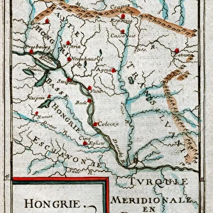
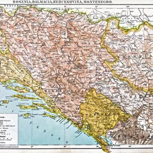
Photographic Print : Austria Hungary map 1893


![]()
Photo Prints from Fine Art Storehouse
Austria Hungary map 1893
Johnsonas Universal Cyclopedia - Charles Kendall - New York 1893
Unleash your creativity and transform your space into a visual masterpiece!
THEPALMER
Media ID 14756578
© This content is subject to copyright
Austria Bavaria Hungary Serbia Bosnia
10"x8" Photo Print
Introducing the exquisite "Austria Hungary Map 1893" print from our Media Storehouse Fine Art Collection. This captivating piece is a reproduction of an original map taken from the esteemed Johnson's Universal Cyclopedia published in New York in 1893. The intricate details of the Austro-Hungarian Empire's territories as they stood over a century ago are beautifully rendered in this vintage map by THEPALMER. Bring a touch of historical charm to your home or office with this authentic and intriguing work of art. Order now and transport yourself back in time.
Photo prints are produced on Kodak professional photo paper resulting in timeless and breath-taking prints which are also ideal for framing. The colors produced are rich and vivid, with accurate blacks and pristine whites, resulting in prints that are truly timeless and magnificent. Whether you're looking to display your prints in your home, office, or gallery, our range of photographic prints are sure to impress. Dimensions refers to the size of the paper in inches.
Our Photo Prints are in a large range of sizes and are printed on Archival Quality Paper for excellent colour reproduction and longevity. They are ideal for framing (our Framed Prints use these) at a reasonable cost. Alternatives include cheaper Poster Prints and higher quality Fine Art Paper, the choice of which is largely dependant on your budget.
Estimated Product Size is 25.4cm x 20.3cm (10" x 8")
These are individually made so all sizes are approximate
Artwork printed orientated as per the preview above, with landscape (horizontal) or portrait (vertical) orientation to match the source image.
FEATURES IN THESE COLLECTIONS
> Fine Art Storehouse
> Map
> Historical Maps
> Europe
> Austria
> Related Images
> Europe
> Bosnia and Herzegovina
> Maps
> Europe
> Hungary
> Related Images
> Europe
> Serbia
> Related Images
EDITORS COMMENTS
In this print titled "Austria Hungary map 1893" we are transported back in time to the late 19th century, where cartography was both an art and a science. This meticulously detailed map, sourced from Johnson's Universal Cyclopedia by Charles Kendall, showcases the vast territories of Austria-Hungary during that era. The rich hues and intricate lines on the print bring to life a world long gone but not forgotten. The borders of Austria, Bavaria, Bosnia, Serbia, and Hungary are clearly marked with precision and accuracy. Each region is distinguished by its own unique characteristics - from the majestic Alpine landscapes in Austria to the vibrant cultural heritage of Hungary. As we delve into this historical artifact captured by THEPALMER for Fine Art Storehouse, we can't help but marvel at how much Europe has transformed over time. It serves as a reminder of the complex geopolitical landscape that once existed within these lands. This photograph invites us to explore our collective past while appreciating the craftsmanship involved in creating such maps. It sparks curiosity about how people navigated through these territories before modern technology made it so effortless. Whether you're an avid history enthusiast or simply captivated by vintage aesthetics, this stunning print will undoubtedly transport you back in time and ignite your imagination as you ponder upon the intricacies of European history.
MADE IN THE USA
Safe Shipping with 30 Day Money Back Guarantee
FREE PERSONALISATION*
We are proud to offer a range of customisation features including Personalised Captions, Color Filters and Picture Zoom Tools
SECURE PAYMENTS
We happily accept a wide range of payment options so you can pay for the things you need in the way that is most convenient for you
* Options may vary by product and licensing agreement. Zoomed Pictures can be adjusted in the Cart.